IMAGES TAKEN NEAR TO
Heol Edward Lewis, HENGOED, CF82 8EJ
Introduction
This page details the photographs taken nearby to Heol Edward Lewis, CF82 8EJ by members of the Geograph project.
The Geograph project started in 2005 with the aim of publishing, organising and preserving representative images for every square kilometre of Great Britain, Ireland and the Isle of Man.

There are currently over 7.5m images from over14,400 individuals and you can help contribute to the project by visiting https://www.geograph.org.uk
Image Map
Images are licensed for reuse under creativecommons.org/licenses/by-sa/2.0
Notes
- Clicking on the map will re-center to the selected point.
- The higher the marker number, the further away the image location is from the centre of the postcode.
Image Listing (96 Images Found)
Images are licensed for reuse under creativecommons.org/licenses/by-sa/2.0
Image
Details
Distance
1

Aneurin Bevan Avenue rooftop solar panels, Gelligaer
On roofs facing southeast.
Image: © Jaggery
Taken: 14 Feb 2019
0.06 miles
2
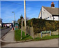
Corner of Rectory Road and Church Road, Gelligaer
The Rectory Road name sign shows LEADING TO ROMAN SITE.
Image: © Jaggery
Taken: 14 Feb 2019
0.06 miles
3

Humps warning signs, Aneurin Bevan Avenue, Gelligaer
The signs facing the B4254 Church Road show Humps for ½ mile. The text is also in Welsh.
Image: © Jaggery
Taken: 14 Feb 2019
0.06 miles
4
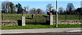
Gates at the entrance to Gelligaer Roman Fort site
From Church Road to the field which was the site of an ancient Roman fort.
Image: © Jaggery
Taken: 14 Feb 2019
0.06 miles
5
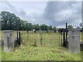
Caer Rufeinig, Gelligaer
Site of Roman fort, Gelligaer.
Image: © Alan Hughes
Taken: 11 Jul 2023
0.06 miles
6

Junction of Church Road and Aneurin Bevan Avenue, Gelligaer
From the left, Aneurin Bevan Avenue joins the B4254 Church Road.
Image: © Jaggery
Taken: 14 Feb 2019
0.07 miles
7

Pink house, Church Road, Gelligaer
Alongside the B4254 Church Road.
Image: © Jaggery
Taken: 14 Feb 2019
0.08 miles
8
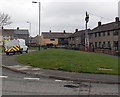
Man up a pole, Gelligaer
A Kelly Communications van is parked in Aneurin Bevan Avenue.
Nearby, a Kelly Communications engineer is working at the top of a telephone pole.
Image: © Jaggery
Taken: 10 May 2013
0.09 miles
9
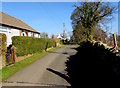
Light and shade, Rectory Road, Gelligaer
From Church Road, Rectory Road leads to the Rhymney Valley Ridgeway Walk.
Image: © Jaggery
Taken: 14 Feb 2019
0.09 miles
10

Culture Clash information board, Gelligaer
The board on the right here https://www.geograph.org.uk/photo/6392389 is at the edge of the site anciently occupied by a Roman fort. The first sentence on the board asks Can you imagine what it is like to be invaded by a completely alien culture? Topics covered include religion, buildings, roads, slaves, fashion, heating and warfare. The information is also in Welsh.
Image: © Jaggery
Taken: 14 Feb 2019
0.10 miles