1
Children’s playground in Penpedairheol
Image: © Alan Hughes
Taken: 11 Jul 2023
0.07 miles
2
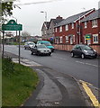
Corner of Mount Pleasant and Berllanlwyd Street, Penpedairheol
Viewed across the B4254. Mount Pleasant houses are on the right.
Image: © Jaggery
Taken: 10 May 2013
0.11 miles
3
Cascade Methodist Church information board, Penpedairheol
The board is outside this http://www.geograph.org.uk/photo/3453579 church.
Image: © Jaggery
Taken: 10 May 2013
0.11 miles
4
Eastern boundary of Penpedairheol
The B4254 reaches Penpedairheol, a village near Gelligaer and Pengam in Caerphilly County Borough.
A literal translation of the name is the top, head or end of four roads.
The houses are in a row named Mount Pleasant.
Image: © Jaggery
Taken: 10 May 2013
0.13 miles
5
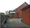
Cascade Methodist Church, Penpedairheol
Image: © Alan Hughes
Taken: 11 Jul 2023
0.13 miles
6
Cascade Methodist Church, Penpedairheol
The church is set back 30 metres from the south side of the B4254 Pengam Road.
Image: © Jaggery
Taken: 10 May 2013
0.13 miles
7
Berllanlwyd Street, Penpedairheol
North along Berllanlwyd Street from the B4254.
Image: © Jaggery
Taken: 14 Feb 2019
0.13 miles
8
Bus stop and shelter near Berllanlwyd Street, Penpedairheol
This stop on the B4254 Pengam Road is for buses to Gilfach and Bargoed.
Image: © Jaggery
Taken: 14 Feb 2019
0.14 miles
9
B4254 at The Square, Penpedairheol
Image: © Colin Pyle
Taken: 21 Apr 2018
0.19 miles
10
Hengoed Road bungalows, Penpedairheol
Derived from a Hindi word meaning in the style of Bengal, bungalow was originally used in English for a lightly-built house, with a veranda and one storey. In current UK usage it is a convenient word for any one-storey dwelling.
Image: © Jaggery
Taken: 22 Aug 2019
0.19 miles


