IMAGES TAKEN NEAR TO
Beatty Street, HENGOED, CF82 8AP
Introduction
This page details the photographs taken nearby to Beatty Street, CF82 8AP by members of the Geograph project.
The Geograph project started in 2005 with the aim of publishing, organising and preserving representative images for every square kilometre of Great Britain, Ireland and the Isle of Man.

There are currently over 7.5m images from over14,400 individuals and you can help contribute to the project by visiting https://www.geograph.org.uk
Image Map
Images are licensed for reuse under creativecommons.org/licenses/by-sa/2.0
Notes
- Clicking on the map will re-center to the selected point.
- The higher the marker number, the further away the image location is from the centre of the postcode.
Image Listing (89 Images Found)
Images are licensed for reuse under creativecommons.org/licenses/by-sa/2.0
Image
Details
Distance
1
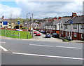
Junction of the A469 New Road and Beatty Street, Tir-y-berth
Signs facing New Road show that Beatty Street is one way and unsuitable for long vehicles. https://www.geograph.org.uk/photo/5805289
Image: © Jaggery
Taken: 26 Apr 2018
0.01 miles
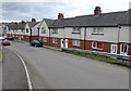
2
No Entry signs, Beatty Street, Tir-y-berth
Two-way Beatty Street on the camera side becomes one-way to the A469 junction 80 metres ahead.
Image: © Jaggery
Taken: 26 Apr 2018
0.02 miles
3
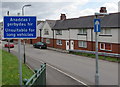
Anaddas i gerbydau hir/Unsuitable for long vehicles, Beatty Street, Tir-y-berth
The Welsh/English sign faces the A469 New Road at the western end of Beatty Street.
Image: © Jaggery
Taken: 26 Apr 2018
0.02 miles
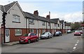
4
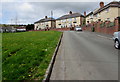
Two rows of houses, Beatty Street, Tir-y-berth
Viewed from the corner of the A469 New Road.
Image: © Jaggery
Taken: 26 Apr 2018
0.02 miles
5
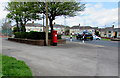
Queen Elizabeth II pillarbox in Tir-y-berth
On the west side of the A469 New Road near New Road Fish Bar.
Image: © Jaggery
Taken: 26 Apr 2018
0.03 miles
6
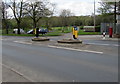
Pedestrian refuge in New Road, Tir-y-berth
Walkers can use the refuge to cross half a road width at a time when traffic is busy on the A469 New Road.
Image: © Jaggery
Taken: 26 Apr 2018
0.03 miles
7
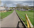
Side road towards the A469 New Road, Tir-y-berth
Viewed from a lockable yellow barrier currently open. A playground https://www.geograph.org.uk/photo/5805374 is ahead on the right.
Image: © Jaggery
Taken: 26 Apr 2018
0.03 miles
8
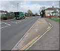
New Road bus stop and shelter, Tir-y-berth
On the east side of the A469 New Road viewed from the corner of Beatty Street.
Image: © Jaggery
Taken: 26 Apr 2018
0.03 miles
9
Tir-y-berth electricity substation
The Western Power Distribution electricity substation is set back from the west side of the A469 New Road at the edge of New Road Fish Bar. The substation identifier is TIR-Y-BERTH S/S 552758
Image: © Jaggery
Taken: 26 Apr 2018
0.04 miles
10
Tir-y-berth Street, Tir-y-berth
Ascending from Beatty Street towards the A469 New Road.
Image: © Jaggery
Taken: 26 Apr 2018
0.04 miles