IMAGES TAKEN NEAR TO
The Avenue, HENGOED, CF82 8AE
Introduction
This page details the photographs taken nearby to The Avenue, CF82 8AE by members of the Geograph project.
The Geograph project started in 2005 with the aim of publishing, organising and preserving representative images for every square kilometre of Great Britain, Ireland and the Isle of Man.

There are currently over 7.5m images from over14,400 individuals and you can help contribute to the project by visiting https://www.geograph.org.uk
Image Map
Images are licensed for reuse under creativecommons.org/licenses/by-sa/2.0
Notes
- Clicking on the map will re-center to the selected point.
- The higher the marker number, the further away the image location is from the centre of the postcode.
Image Listing (84 Images Found)
Images are licensed for reuse under creativecommons.org/licenses/by-sa/2.0
Image
Details
Distance
1
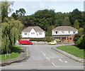
Houses, The Avenue, Ystrad Mynach
Viewed from the edge of Pengam Road, near the New Road (A469) roundabout.
Image: © Jaggery
Taken: 27 Aug 2010
0.03 miles
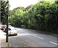
2
East along Pengam Road, Ystrad Mynach
Viewed from the Davies Street junction. Ahead for the A469.
Image: © Jaggery
Taken: 10 Dec 2018
0.08 miles
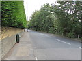
3
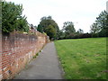
Pavement separated from A469, Ystrad Mynach
For about 200 metres, the pavement on the west side of New Road (A469) is separated from the roadway by a grassy bank.
Image: © Jaggery
Taken: 27 Aug 2010
0.10 miles
4
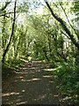
Shared path in woodland south of Hengoed on NCN47
Image: © David Smith
Taken: 27 Sep 2021
0.12 miles
6
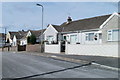
Bungalows, The Avenue, Ystrad Mynach
Bungalows of the north side of The Avenue, near the turning for Avenue Close. http://www.geograph.org.uk/photo/2036140
Image: © Jaggery
Taken: 27 Aug 2010
0.13 miles
7
Neighbourhood Watch Area notice, Park Road, Hengoed
On the pole in the background here. https://www.geograph.org.uk/photo/6246136
Image: © Jaggery
Taken: 23 Aug 2019
0.13 miles
8
Shades of green, Park Road, Hengoed
Green hedge, green trees, green telecoms cabinet.
Image: © Jaggery
Taken: 23 Aug 2019
0.13 miles
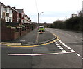
9
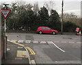
Ildiwch/Give Way, Davies Street, Ystrad Mynach
The Welsh/English sign faces Davies Street at the Pengam Road junction.
Image: © Jaggery
Taken: 10 Dec 2018
0.13 miles
10
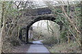
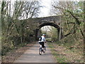
Road bridge over cycle route
Bridge Image over National Cycle Route 47 which here is also part of the Rhymney Valley Ridgeway Walk.
Image: © M J Roscoe
Taken: 24 Mar 2018
0.14 miles