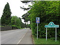
IMAGES TAKEN NEAR TO
Caerphilly Road, HENGOED, CF82 7XW
Introduction
This page details the photographs taken nearby to Caerphilly Road, CF82 7XW by members of the Geograph project.
The Geograph project started in 2005 with the aim of publishing, organising and preserving representative images for every square kilometre of Great Britain, Ireland and the Isle of Man.

There are currently over 7.5m images from over14,400 individuals and you can help contribute to the project by visiting https://www.geograph.org.uk
Image Map
Images are licensed for reuse under creativecommons.org/licenses/by-sa/2.0
Notes
- Clicking on the map will re-center to the selected point.
- The higher the marker number, the further away the image location is from the centre of the postcode.
Image Listing (141 Images Found)
Images are licensed for reuse under creativecommons.org/licenses/by-sa/2.0
Image
Details
Distance
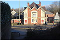
2
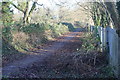
Path between graveyard and school grounds
The graveyard of Holy Trinity Church is on the left.
Image: © M J Roscoe
Taken: 28 Dec 2017
0.05 miles
3
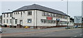
Penallta RFC building, Ystrad Mynach
The rugby football club's building is located on Caerphilly Road. Penallta RFC was formed in 1952 by miners from Penallta Colliery, hence their nickname, The Pitmen.
Image: © Jaggery
Taken: 27 Aug 2010
0.06 miles
4
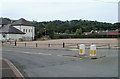
Former location of Allied Carpets, Ystrad Mynach
The vacant site located on the north side of the Penallta RFC building http://www.geograph.org.uk/photo/2037958 was formerly occupied by Allied Carpets premises. The building was demolished after they relocated to Porth, Rhondda Cynon Taf.
Image: © Jaggery
Taken: 27 Aug 2010
0.06 miles
5
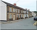
Central Street, Ystrad Mynach
Houses on the SW side of Central Street, which runs for nearly 400 metres from here to the junction with Lewis Street.
Image: © Jaggery
Taken: 27 Aug 2010
0.06 miles
6
Oak Leaf roundabout, Ystrad Mynach
In the middle of the junction of the A472, Caerphilly Road and Commercial Street. Best viewed from above, a depiction of a giant oak leaf is on the roundabout. A nearby information board records that the oak leaf continues the symbolic nature of the pub on the right (Ye Olde Royal Oak) https://www.geograph.org.uk/photo/5992831 as a focal point for directions. Names for local taverns are centuries old, dating from a time when many of their customers were unable to read. A public house was easily recognised by a distinctive image such as an oak tree.
Image: © Jaggery
Taken: 4 Dec 2018
0.07 miles
7
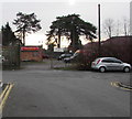
Entrance to the Trafalgar Cleaning Equipment site, Ystrad Mynach
Kärcher main dealer viewed from the southern end of Central Street.
Kärcher is a German company which makes high-pressure cleaners, floor care equipment etc.
Image: © Jaggery
Taken: 4 Dec 2018
0.07 miles
8
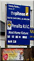
Penallta RFC (The Pitmen) information board, Ystrad Mynach
On the right here. https://www.geograph.org.uk/photo/5995531
Image: © Jaggery
Taken: 4 Dec 2018
0.07 miles
9
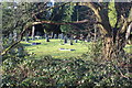
Graveyard, Holy Trinity Church, Ystrad Mynach
Part of the graveyard viewed from a footpath.
Image: © M J Roscoe
Taken: 28 Dec 2017
0.07 miles
10
Ye Olde Royal Oak, Ystrad Mynach
Public house next to a roundabout viewed from across the A472; the bus shelter (right) is on Commercial Street.
Image: © M J Roscoe
Taken: 28 Dec 2017
0.07 miles