IMAGES TAKEN NEAR TO
Willow Way, HENGOED, CF82 7TR
Introduction
This page details the photographs taken nearby to Willow Way, CF82 7TR by members of the Geograph project.
The Geograph project started in 2005 with the aim of publishing, organising and preserving representative images for every square kilometre of Great Britain, Ireland and the Isle of Man.

There are currently over 7.5m images from over14,400 individuals and you can help contribute to the project by visiting https://www.geograph.org.uk
Image Map
Images are licensed for reuse under creativecommons.org/licenses/by-sa/2.0
Notes
- Clicking on the map will re-center to the selected point.
- The higher the marker number, the further away the image location is from the centre of the postcode.
Image Listing (5 Images Found)
Images are licensed for reuse under creativecommons.org/licenses/by-sa/2.0
Image
Details
Distance
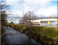
3
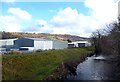
Rhymney River Flood Bank
This levee beside the Rhymney River protects the business units.
Image: © Des Blenkinsopp
Taken: 20 Feb 2014
0.23 miles
4
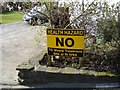
Protest sign, Twyn Shon-Ifan
A waste treatment plant is proposed nearby, at the site of the former St Ives factory. These signs are much in evidence, locally.
Image: © Roger Cornfoot
Taken: 19 Mar 2007
0.24 miles
5
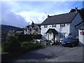
Houses at Twyn Shon-Ifan
Overlooking the Rhymney valley.
Image: © Roger Cornfoot
Taken: 19 Mar 2007
0.25 miles