IMAGES TAKEN NEAR TO
South Road, HENGOED, CF82 7ST
Introduction
This page details the photographs taken nearby to South Road, CF82 7ST by members of the Geograph project.
The Geograph project started in 2005 with the aim of publishing, organising and preserving representative images for every square kilometre of Great Britain, Ireland and the Isle of Man.

There are currently over 7.5m images from over14,400 individuals and you can help contribute to the project by visiting https://www.geograph.org.uk
Image Map
Images are licensed for reuse under creativecommons.org/licenses/by-sa/2.0
Notes
- Clicking on the map will re-center to the selected point.
- The higher the marker number, the further away the image location is from the centre of the postcode.
Image Listing (37 Images Found)
Images are licensed for reuse under creativecommons.org/licenses/by-sa/2.0
Image
Details
Distance
1
Ysgol Gymraeg Penalltau, Hengoed
The £3 million school was officially opened in the autumn of 2009. The purpose-built school, located on the Cwm Calon estate, provides Welsh medium education for pupils aged 3-11. A Welsh medium school is one in which all lessons are delivered through the medium of the Welsh language.
Image: © Jaggery
Taken: 25 Feb 2012
0.15 miles
2
Hope Church, Penybryn
Set back from and below the east side of Penybryn Terrace, accessed via a zigzag ramp.
In February 2019 the church nameboard https://www.geograph.org.uk/photo/6058851 shows Hope @ Bethel & Calvary.
Image: © Jaggery
Taken: 13 Feb 2019
0.16 miles
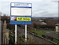
3

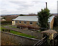
Penybryn Engineering Ltd, Penybryn
On the east side of Penybryn Terrace in Penybryn near Gelligaer.
Image: © Jaggery
Taken: 13 Feb 2019
0.16 miles
4
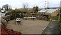
Wooden benches near Hope Church, Penybryn
On the east side of Penybryn Terrace. Hope Church https://www.geograph.org.uk/photo/6058848 is below road level on the right.
Image: © Jaggery
Taken: 13 Feb 2019
0.16 miles
5
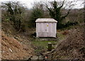
Penybryn electricity substation
Set back 12 metres from Penybryn Terrace, accessed via steps, the large grey cabinet is a Western Power Distribution electricity substation. Its identifier is PENYBRYN S/S 552693
Image: © Jaggery
Taken: 13 Feb 2019
0.16 miles
6
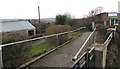
Zigzag ramp to Hope Church, Penybryn
Descending from Penybryn Terrace to Hope Church. https://www.geograph.org.uk/photo/6058848
Image: © Jaggery
Taken: 13 Feb 2019
0.16 miles
7
Hope Church nameboard, Penybryn
In February 2019 the nameboard alongside Penybryn Terrace shows Hope @ Bethel & Calvary.
The church https://www.geograph.org.uk/photo/6058848 is below road level on the right, accessed via a zigzag ramp.
Image: © Jaggery
Taken: 13 Feb 2019
0.16 miles
8
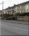
King George V postbox in a Penybryn wall
In a wall on the west side of Penybryn Terrace in Penybryn near Gelligaer.
Image: © Jaggery
Taken: 13 Feb 2019
0.17 miles
9
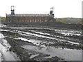
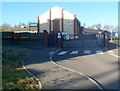
Penallta Colliery Building, Nr Ystrad Mynach
Image: © Kev Griffin
Taken: 16 Nov 2004
0.17 miles
10

Path to West Road in Penallta Industrial Estate
Descending from near Penybryn Terrace in Penybryn.
Image: © Jaggery
Taken: 13 Feb 2019
0.17 miles