IMAGES TAKEN NEAR TO
New Road, HENGOED, CF82 7SG
Introduction
This page details the photographs taken nearby to New Road, CF82 7SG by members of the Geograph project.
The Geograph project started in 2005 with the aim of publishing, organising and preserving representative images for every square kilometre of Great Britain, Ireland and the Isle of Man.

There are currently over 7.5m images from over14,400 individuals and you can help contribute to the project by visiting https://www.geograph.org.uk
Image Map
Images are licensed for reuse under creativecommons.org/licenses/by-sa/2.0
Notes
- Clicking on the map will re-center to the selected point.
- The higher the marker number, the further away the image location is from the centre of the postcode.
Image Listing (142 Images Found)
Images are licensed for reuse under creativecommons.org/licenses/by-sa/2.0
Image
Details
Distance
1
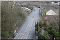
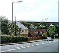
New Road, A469, from above
The A469 seen from near the western (Hengoed) end of the Hengoed Viaduct. The centre of the road is marked off because one of the piers for the viaduct is in the middle of the road.
Image: © M J Roscoe
Taken: 24 Mar 2018
0.01 miles
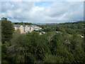
3

New Road (A469), Hengoed
This is the view looking north from the Hengoed end of the Maesycwmmer - Hengoed Viaduct.
Image: © Robin Drayton
Taken: 23 Jan 2010
0.02 miles
5
Road & river under Hengoed Viaduct
Image: © Hazel Stanmore-Richards
Taken: 4 Sep 2010
0.04 miles
6
Houses, New Road, Hengoed
Located alongside the A469 (New Road), adjacent to a former railway viaduct. http://www.geograph.org.uk/photo/2036662
Image: © Jaggery
Taken: 27 Aug 2010
0.04 miles
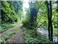
7
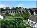
Hengoed Viaduct at Maesycwmmer
This is a disused railway, now a path and cycle track.
Image: © Ruth Sharville
Taken: 16 Aug 2013
0.06 miles
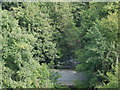
8
Hengoed viaduct
The Hengoed to Maesycwmmer viaduct opened in 1858 and was last used in June 1964 when the line fell to the Beeching axe. It is now part of the National Cycle Route network.
https://en.wikipedia.org/wiki/Hengoed_Viaduct
Image: © Alan Hughes
Taken: 1 Aug 2021
0.06 miles
9

Maesycwmmer viaduct
Taken from a Newport-Brecon train shortly before closure of the line. This part of the Brecon and Merthyr Railway was completely dismantled after closure; there is another railway on the opposite side of the valley to the left which still carries passenger trains
Image: © Flying Stag
Taken: Unknown
0.06 miles
10

Hengoed
Hengoed, the viaduct, now a cycle track walkway, a former railway
Image: © Colin Prosser
Taken: 7 May 2015
0.06 miles