IMAGES TAKEN NEAR TO
St. Annes Gardens, HENGOED, CF82 7QR
Introduction
This page details the photographs taken nearby to St. Annes Gardens, CF82 7QR by members of the Geograph project.
The Geograph project started in 2005 with the aim of publishing, organising and preserving representative images for every square kilometre of Great Britain, Ireland and the Isle of Man.

There are currently over 7.5m images from over14,400 individuals and you can help contribute to the project by visiting https://www.geograph.org.uk
Image Map
Images are licensed for reuse under creativecommons.org/licenses/by-sa/2.0
Notes
- Clicking on the map will re-center to the selected point.
- The higher the marker number, the further away the image location is from the centre of the postcode.
Image Listing (62 Images Found)
Images are licensed for reuse under creativecommons.org/licenses/by-sa/2.0
Image
Details
Distance
1
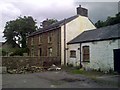
Gelli Deg Isaf
Farmhouse existed before the village. Land was bought from the Farmer. Only this building is left now, surrounded by Victorian and modern estates.
Image: © Al Evans
Taken: Unknown
0.11 miles
4
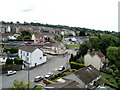
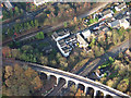
Northwest Maesycwmmer
Viewed from the eastern end of a former railway viaduct http://www.geograph.org.uk/photo/2036662 now part of National Cycle Network route 47.
Image: © Jaggery
Taken: 27 Aug 2010
0.13 miles
6
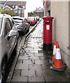
Queen Elizabeth II pillarbox, West Avenue, Maesycwmmer
Behind the car on the left here https://www.geograph.org.uk/photo/5991857 outside the former village post office.
Image: © Jaggery
Taken: 30 Nov 2018
0.16 miles
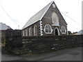
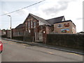
7
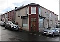
Former village post office, Maesycwmmer
On the corner of West Avenue and North Avenue viewed in November 2018.
An August 2011 Google Earth Street View shows a post office on this corner.
The red pillarbox https://www.geograph.org.uk/photo/5991861 behind the car on the left is a reminder of the building's former use.
Image: © Jaggery
Taken: 30 Nov 2018
0.16 miles
8
The Junction public house and Hengoed viaduct
Hengoed viaduct and Junction public house by Phil Matthews
Image: © phil matthews
Taken: 8 Dec 2005
0.17 miles
9
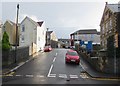
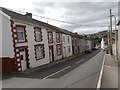
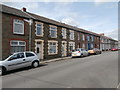
West Avenue, Maesycwmmer
Ascending from Tabor Road towards the North Avenue crossroads.
The Old Police Station https://www.geograph.org.uk/photo/5991870 is on the right.
Image: © Jaggery
Taken: 30 Nov 2018
0.17 miles