1
The Junction public house and Hengoed viaduct
Hengoed viaduct and Junction public house by Phil Matthews
Image: © phil matthews
Taken: 8 Dec 2005
0.11 miles
2
Maesycwmmer Primary School
Image: © John Lord
Taken: 24 Aug 2017
0.15 miles
3
Houses and trees above Main Road, Maesycwmmer
Above the east side of Main Road, viewed across the A472.
Image: © Jaggery
Taken: 30 Nov 2018
0.15 miles
4
Mount Pleasant Evangelical Baptist Church, Maesycwmmer
The opening services for this building were held on February 5th 1905. The congregation had moved from https://www.geograph.org.uk/photo/5509975 .
Image: © Robin Drayton
Taken: 23 Jan 2010
0.15 miles
5
Mount Pleasant Evangelical Baptist Church, Maesycwmmer
Image: © John Lord
Taken: 24 Aug 2017
0.16 miles
6
West side of Mount Pleasant Evangelical Baptist Church, Maesycwmmer
Partly hidden by a tree. Viewed across the A472 Main Road.
Image: © Jaggery
Taken: 30 Nov 2018
0.16 miles
7
Main Road shops, Maesycwmmer
Part of a row of shops on the east side of Main Road. Seen here are Glam Hair Studio, Meridian blinds & curtains and Tsoi House, Chinese and English takeaway.
Confusingly (and possibly hazardously) for the visitor, the metal barrier is not a dual carriageway separator. There is one lane in each direction on the camera side of the barrier. The roadway on the other side of the barrier is intended for those visiting the shops : there, the flow of traffic is one way, from left to right. The barrier ends near the left edge of the photo, adjacent to a bus stop just out of shot.
Image: © Jaggery
Taken: 27 Aug 2010
0.17 miles
8
Northwest Maesycwmmer
Viewed from the eastern end of a former railway viaduct http://www.geograph.org.uk/photo/2036662 now part of National Cycle Network route 47.
Image: © Jaggery
Taken: 27 Aug 2010
0.17 miles
9
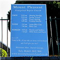
Information board outside Mount Pleasant Evangelical Baptist Church, Maesycwmmer
Located here https://www.geograph.org.uk/photo/5989875 facing Main Road viewed on November 30th 2018.
Image: © Jaggery
Taken: 30 Nov 2018
0.17 miles
10
Semis above Main Road, Maesycwmmer
Two semi-detached houses above the east side of Main Road.
A church https://www.geograph.org.uk/photo/5989875 is behind the tree on the right.
Image: © Jaggery
Taken: 30 Nov 2018
0.18 miles


