IMAGES TAKEN NEAR TO
Y Glyn, HENGOED, CF82 7PF
Introduction
This page details the photographs taken nearby to Y Glyn, CF82 7PF by members of the Geograph project.
The Geograph project started in 2005 with the aim of publishing, organising and preserving representative images for every square kilometre of Great Britain, Ireland and the Isle of Man.

There are currently over 7.5m images from over14,400 individuals and you can help contribute to the project by visiting https://www.geograph.org.uk
Image Map
Images are licensed for reuse under creativecommons.org/licenses/by-sa/2.0
Notes
- Clicking on the map will re-center to the selected point.
- The higher the marker number, the further away the image location is from the centre of the postcode.
Image Listing (4 Images Found)
Images are licensed for reuse under creativecommons.org/licenses/by-sa/2.0
Image
Details
Distance
2
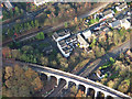
The Junction public house and Hengoed viaduct
Hengoed viaduct and Junction public house by Phil Matthews
Image: © phil matthews
Taken: 8 Dec 2005
0.22 miles
3

Houses and trees above Main Road, Maesycwmmer
Above the east side of Main Road, viewed across the A472.
Image: © Jaggery
Taken: 30 Nov 2018
0.24 miles
4
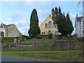
Mount Pleasant Evangelical Baptist Church, Maesycwmmer
The opening services for this building were held on February 5th 1905. The congregation had moved from https://www.geograph.org.uk/photo/5509975 .
Image: © Robin Drayton
Taken: 23 Jan 2010
0.25 miles