IMAGES TAKEN NEAR TO
Heol Celyn, HENGOED, CF82 7NS
Introduction
This page details the photographs taken nearby to Heol Celyn, CF82 7NS by members of the Geograph project.
The Geograph project started in 2005 with the aim of publishing, organising and preserving representative images for every square kilometre of Great Britain, Ireland and the Isle of Man.

There are currently over 7.5m images from over14,400 individuals and you can help contribute to the project by visiting https://www.geograph.org.uk
Image Map
Images are licensed for reuse under creativecommons.org/licenses/by-sa/2.0
Notes
- Clicking on the map will re-center to the selected point.
- The higher the marker number, the further away the image location is from the centre of the postcode.
Image Listing (106 Images Found)
Images are licensed for reuse under creativecommons.org/licenses/by-sa/2.0
Image
Details
Distance
1
East along Heol Derw, Hengoed
Viewed from the corner of Hengoed Road. Heol Derw leads to King's Hill out of shot ahead.
Image: © Jaggery
Taken: 23 Aug 2019
0.03 miles
2
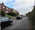
Heol Uchaf, Hengoed
From the east side of Hengoed Road, Heol Uchaf leads to James Terrace and Mount Pleasant.
Image: © Jaggery
Taken: 23 Aug 2019
0.04 miles
3
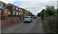
East along Heol Celyn, Hengoed
Viewed from near the corner of Hengoed Road. Heol Celyn leads to King's Hill out of shot ahead.
Image: © Jaggery
Taken: 23 Aug 2019
0.05 miles
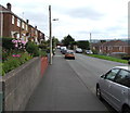
4
Mount Pleasant, Hengoed
From the east side of Hengoed Road, Mount Pleasant leads to James Terrace
and King's Hill. A sign near the camera shows No footway for 130 yds.
Image: © Jaggery
Taken: 23 Aug 2019
0.07 miles
5
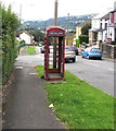
Shell of a former red phonebox, Hengoed Road, Hengoed
Located near the corner of Heol Celyn viewed in August 2019.
The telephone equipment and the door have been removed.
https://www.geograph.org.uk/photo/6245229 to a closer view.
Image: © Jaggery
Taken: 23 Aug 2019
0.08 miles
6
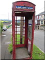
Inside a former red phonebox, Hengoed Road, Hengoed
The telephone equipment and the door have gone. BT Payphone Kiosk Removal notices in English and Welsh are on the box wall on the right. https://www.geograph.org.uk/photo/6245227 to a broader view.
Image: © Jaggery
Taken: 23 Aug 2019
0.08 miles
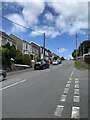
7
Towards Heol Dewi, Hengoed
Road from the east side of Hengoed Road towards Heol Dewi.
Image: © Jaggery
Taken: 23 Aug 2019
0.08 miles
9
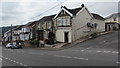
Unnamed corner shop, Hengoed Road, Hengoed
Viewed from the corner of Heol Derw in August 2019. The HENGOED STORES name sign seen in a September 2010 Google Street View has gone, as have the ground floor windows.
Image: © Jaggery
Taken: 23 Aug 2019
0.09 miles
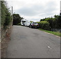
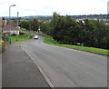
10
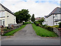
Side road on the north side of Park Road, Hengoed
Ascending towards Heol Dewi.
Image: © Jaggery
Taken: 23 Aug 2019
0.09 miles