IMAGES TAKEN NEAR TO
Cefn Road, HENGOED, CF82 7NB
Introduction
This page details the photographs taken nearby to Cefn Road, CF82 7NB by members of the Geograph project.
The Geograph project started in 2005 with the aim of publishing, organising and preserving representative images for every square kilometre of Great Britain, Ireland and the Isle of Man.

There are currently over 7.5m images from over14,400 individuals and you can help contribute to the project by visiting https://www.geograph.org.uk
Image Map (Loading...)


Getting Data...Please wait
Leaflet Map data © OpenStreetMap
Images are licensed for reuse under creativecommons.org/licenses/by-sa/2.0
Notes
- Clicking on the map will re-center to the selected point.
- The higher the marker number, the further away the image location is from the centre of the postcode.
Image Listing (67 Images Found)
Images are licensed for reuse under creativecommons.org/licenses/by-sa/2.0
Image
Details
Distance
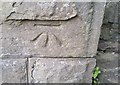
1
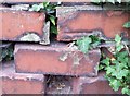
Ordnance Survey Cut Mark
This OS cut mark can be found on the gatepost of No51 Brynavon Terrace. It marks a point 142.692m above mean sea level.
Image: © Adrian Dust
Taken: 8 Jun 2019
0.05 miles
2
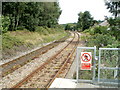
The view NE from Hengoed railway station
Hengoed station is on the Rhymney Line of the Valley Lines network. The next station is this direction is Pengam.
Image: © Jaggery
Taken: 27 Aug 2010
0.11 miles
3
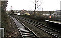
Rhymney Line railway NE of Hengoed railway station
Next station in this direction is Pengoed.
Image: © Jaggery
Taken: 30 Nov 2018
0.14 miles
4
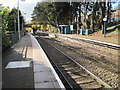
Hengoed (Low Level) railway station, Gwent
Opened in 1858 by the Rhymney Railway on its line from Cardiff to Rhymney. View south towards Ystrad Mynnach and Cardiff. The station used to have the suffix 'Low Level'. The bridge at the south end of the platform used to carry Hengoed 'High Level' station on the Taff Vale Extension Railway. That closed in 1964.
Image: © Nigel Thompson
Taken: 10 Nov 2012
0.16 miles
5
Hengoed crossroads
The junctions of King's Hill, Park Road and Brynavon Terrace viewed from Hengoed railway station.
Image: © Jaggery
Taken: 30 Nov 2018
0.16 miles
6
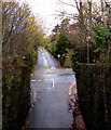
New Road, A469, from above
The A469 seen from near the western (Hengoed) end of the Hengoed Viaduct. The centre of the road is marked off because one of the piers for the viaduct is in the middle of the road.
Image: © M J Roscoe
Taken: 24 Mar 2018
0.16 miles
7

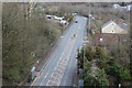
New Road (A469), Hengoed
This is the view looking north from the Hengoed end of the Maesycwmmer - Hengoed Viaduct.
Image: © Robin Drayton
Taken: 23 Jan 2010
0.17 miles
8
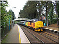
Class 37 at Hengoed
Class 37 No. 37421 heads a Cardiff Canton to Rhymney crew training run at Hengoed station.
Image: © Gareth James
Taken: 30 Sep 2019
0.17 miles
9
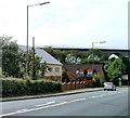
Houses, New Road, Hengoed
Located alongside the A469 (New Road), adjacent to a former railway viaduct. http://www.geograph.org.uk/photo/2036662
Image: © Jaggery
Taken: 27 Aug 2010
0.17 miles
10
Ordnance Survey Cut Mark
This OS cut mark can be found on the south buttress of the railway bridge. It marks a point 132.478m above mean sea level.
Image: © Adrian Dust
Taken: 8 Jun 2019
0.17 miles