IMAGES TAKEN NEAR TO
Ael-y-Bryn, HENGOED, CF82 7LT
Introduction
This page details the photographs taken nearby to Ael-y-Bryn, CF82 7LT by members of the Geograph project.
The Geograph project started in 2005 with the aim of publishing, organising and preserving representative images for every square kilometre of Great Britain, Ireland and the Isle of Man.

There are currently over 7.5m images from over14,400 individuals and you can help contribute to the project by visiting https://www.geograph.org.uk
Image Map
Images are licensed for reuse under creativecommons.org/licenses/by-sa/2.0
Notes
- Clicking on the map will re-center to the selected point.
- The higher the marker number, the further away the image location is from the centre of the postcode.
Image Listing (140 Images Found)
Images are licensed for reuse under creativecommons.org/licenses/by-sa/2.0
Image
Details
Distance


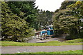
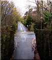
4
Junction of Ael-y-bryn and Park Road, Hengoed
Ael-y-bryn ascends away from Park Road.
Image: © Jaggery
Taken: 23 Aug 2019
0.01 miles
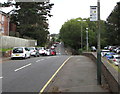
5
Ael-y-bryn, Hengoed
Cul-de-sac on the northwest side of Park Road near Hengoed railway station.
Image: © Jaggery
Taken: 23 Aug 2019
0.02 miles
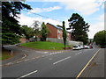
6
Park Road bus stop near Hengoed railway station
In August 2019, the sign shows that this is a stop on bus route 11 to Gelligaer.
Image: © Jaggery
Taken: 23 Aug 2019
0.02 miles
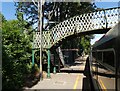
7
View of a footbridge from a footbridge, Rhymney Line, Hengoed
Hengoed railway station footbridge viewed from this https://www.geograph.org.uk/photo/6000944 footbridge a few metres south of the station.
Image: © Jaggery
Taken: 30 Nov 2018
0.03 miles
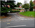
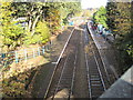
9
Hengoed crossroads
The junctions of King's Hill, Park Road and Brynavon Terrace viewed from Hengoed railway station.
Image: © Jaggery
Taken: 30 Nov 2018
0.03 miles
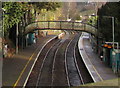
10
Hengoed (Low Level) railway station, Gwent
Opened in 1858 by the Rhymney Railway on its line from Cardiff to Rhymney. View north towards Pengam and Rhymney. Taken from the site of the former 'High Level' station which closed in 1964.
Image: © Nigel Thompson
Taken: 10 Nov 2012
0.03 miles