IMAGES TAKEN NEAR TO
Hengoed Avenue, HENGOED, CF82 7LE
Introduction
This page details the photographs taken nearby to Hengoed Avenue, CF82 7LE by members of the Geograph project.
The Geograph project started in 2005 with the aim of publishing, organising and preserving representative images for every square kilometre of Great Britain, Ireland and the Isle of Man.

There are currently over 7.5m images from over14,400 individuals and you can help contribute to the project by visiting https://www.geograph.org.uk
Image Map
Images are licensed for reuse under creativecommons.org/licenses/by-sa/2.0
Notes
- Clicking on the map will re-center to the selected point.
- The higher the marker number, the further away the image location is from the centre of the postcode.
Image Listing (52 Images Found)
Images are licensed for reuse under creativecommons.org/licenses/by-sa/2.0
Image
Details
Distance
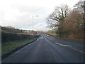
1
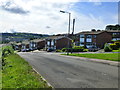
Looking down the hill, Hengoed Avenue, Cefn Hengoed
Image: © Ruth Sharville
Taken: 16 Aug 2013
0.13 miles
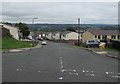
2
Hengoed Hall Drive, Cefn Hengoed
The Woodland Place junction is on the left.
Image: © Jaggery
Taken: 23 Aug 2019
0.16 miles
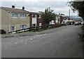
3

View from the top of the hill at Hengoed Avenue, Cefn Hengoed
Image: © Ruth Sharville
Taken: 16 Aug 2013
0.16 miles
4
Down Woodland Place, Cefn Hengoed
From Hengoed Hall Drive, Woodland Place descends towards Birch Crescent and Hengoed Crescent.
Image: © Jaggery
Taken: 23 Aug 2019
0.18 miles
5
Woodland Place, Cefn Hengoed
Viewed from the corner of Hengoed Crescent. Woodland Place leads to Hengoed Hall Drive.
Image: © Jaggery
Taken: 22 Aug 2019
0.19 miles
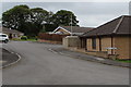
6
Hengoed Hall Close houses, Hengoed
Viewed from Hengoed Road across a burial ground perimeter wall. Hengoed Chapel is on the right. https://www.geograph.org.uk/photo/6248555
Image: © Jaggery
Taken: 23 Aug 2019
0.19 miles
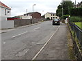
7
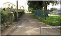
Lane from Hengoed Road towards Hengoed Hall Drive, Hengoed
Metal barriers near the camera prevent the passage of motor vehicles.
The green railings are at the perimeter of Hengoed Primary School.
Image: © Jaggery
Taken: 23 Aug 2019
0.20 miles
8
Dan-y-coed, Hengoed
Dan-y-coed is a cul-de-sac on the east side of Hengoed Road.
Image: © Jaggery
Taken: 22 Aug 2019
0.20 miles
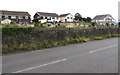
10
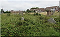
Overgrown burial ground in Hengoed
On the east side of Hengoed Road to the north of Hengoed Chapel.
Image: © Jaggery
Taken: 23 Aug 2019
0.20 miles