1
Hengoed Hall Drive, Cefn Hengoed
The Woodland Place junction is on the left.
Image: © Jaggery
Taken: 23 Aug 2019
0.11 miles
2
Looking down the hill, Hengoed Avenue, Cefn Hengoed
Image: © Ruth Sharville
Taken: 16 Aug 2013
0.12 miles
3
Hengoed Hall Close houses, Hengoed
Viewed from Hengoed Road across a burial ground perimeter wall. Hengoed Chapel is on the right. https://www.geograph.org.uk/photo/6248555
Image: © Jaggery
Taken: 23 Aug 2019
0.14 miles
4
Down Woodland Place, Cefn Hengoed
From Hengoed Hall Drive, Woodland Place descends towards Birch Crescent and Hengoed Crescent.
Image: © Jaggery
Taken: 23 Aug 2019
0.14 miles
5
Dan-y-coed, Hengoed
Dan-y-coed is a cul-de-sac on the east side of Hengoed Road.
Image: © Jaggery
Taken: 22 Aug 2019
0.14 miles
6
Overgrown burial ground in Hengoed
On the east side of Hengoed Road to the north of Hengoed Chapel.
Image: © Jaggery
Taken: 23 Aug 2019
0.15 miles
7
Lane from Hengoed Road towards Hengoed Hall Drive, Hengoed
Metal barriers near the camera prevent the passage of motor vehicles.
The green railings are at the perimeter of Hengoed Primary School.
Image: © Jaggery
Taken: 23 Aug 2019
0.15 miles
8
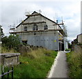
Scaffolding and metal sheeting on Hengoed Chapel in August 2019
Set back from the east side of Hengoed Road in Hengoed near Cefn Hengoed.
The building dated 1829 replaced the original chapel of 1710. Grade II listed in 1993.
Image: © Jaggery
Taken: 23 Aug 2019
0.15 miles
9
Hengoed Road bungalows, Hengoed
The bungalow on the left is on the corner of Dan-y-coed. https://www.geograph.org.uk/photo/6244730
Image: © Jaggery
Taken: 22 Aug 2019
0.16 miles
10
Valley View Care Home, Hengoed
Viewed across Hengoed Road.
Image: © Jaggery
Taken: 22 Aug 2019
0.16 miles


