1
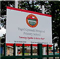
Ysgol Gynradd Hengoed/Hengoed Primary School nameboard, Hengoed
Welsh/English nameboard facing Hengoed Road. The school badge/crest depicts Hengoed railway viaduct.
Image: © Jaggery
Taken: 23 Aug 2019
0.01 miles
2
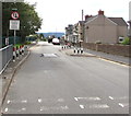
Traffic calming near Hengoed Primary School
A speed bump is in the middle of a narrow part of Hengoed Road.
Vehicles on the camera side must give way to oncoming traffic.
Image: © Jaggery
Taken: 23 Aug 2019
0.01 miles
3
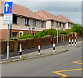
Young Lungs at Play - Smoke Free Zone notice, Hengoed
On perimeter railings near an entrance to Hengoed Primary
School from Hengoed Road. The text is also in Welsh.
Image: © Jaggery
Taken: 23 Aug 2019
0.02 miles
4
Hengoed Road semis, Hengoed
Semi-detached houses on the west side of Hengoed Road south of the Trem Penallta junction. Ahead for Ystrad Mynach.
Image: © Jaggery
Taken: 23 Aug 2019
0.02 miles
5
Hengoed Road semis, Hengoed
Semi-detached houses on the west side of Hengoed Road near the corner of Trem Penallta (ahead).
The yellow road markings are part of the Keep Clear Zone outside Hengoed Primary School.
Image: © Jaggery
Taken: 23 Aug 2019
0.02 miles
6
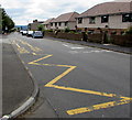
Zigzag yellow markings on Hengoed Road, Hengoed
Marking the Keep Clear Zone outside Hengoed Primary School.
Image: © Jaggery
Taken: 23 Aug 2019
0.02 miles
7
Hengoed Primary School
Image: © John Lord
Taken: 26 Aug 2017
0.02 miles
8
School entrance gates, Hengoed Road, Hengoed
Entrance to Hengoed Primary School.
Image: © Jaggery
Taken: 23 Aug 2019
0.02 miles
9
Ordnance Survey Cut Mark
This OS cut mark can be found on No6 Chapel Terrace. It marks a point 203.299m above mean sea level.
Image: © Adrian Dust
Taken: 8 Jun 2019
0.02 miles
10
Hengoed Road electricity substation near a school, Hengoed
Western Power Distribution electricity substation in a locked enclosure.
Hengoed Primary School is on the right.
Image: © Jaggery
Taken: 23 Aug 2019
0.03 miles


