IMAGES TAKEN NEAR TO
Graig Road, HENGOED, CF82 7JJ
Introduction
This page details the photographs taken nearby to Graig Road, CF82 7JJ by members of the Geograph project.
The Geograph project started in 2005 with the aim of publishing, organising and preserving representative images for every square kilometre of Great Britain, Ireland and the Isle of Man.

There are currently over 7.5m images from over14,400 individuals and you can help contribute to the project by visiting https://www.geograph.org.uk
Image Map
Images are licensed for reuse under creativecommons.org/licenses/by-sa/2.0
Notes
- Clicking on the map will re-center to the selected point.
- The higher the marker number, the further away the image location is from the centre of the postcode.
Image Listing (110 Images Found)
Images are licensed for reuse under creativecommons.org/licenses/by-sa/2.0
Image
Details
Distance
1
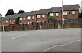
Old School Grange, Hengoed
Cul-de-sac on the west side of Hengoed Road.
Image: © Jaggery
Taken: 23 Aug 2019
0.03 miles
3
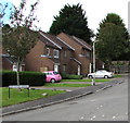
Houses on the southeast side of Old School Grange, Hengoed
One online source states that Old School Grange is built on the site of an infants & juniors school destroyed by fire in 1960.
Image: © Jaggery
Taken: 23 Aug 2019
0.06 miles
4
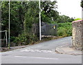
Graig Road electricity substation, Hengoed
The Western Power Distribution electricity substation is in an enclosure at the eastern end of Graig Road.
Image: © Jaggery
Taken: 23 Aug 2019
0.07 miles
5
Row of seven brick houses, Hengoed Road, Hengoed
The house on the left is on the corner of Old School Grange. https://www.geograph.org.uk/photo/6245234
Image: © Jaggery
Taken: 23 Aug 2019
0.07 miles
6
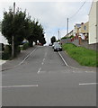
West along Ashgrove, Hengoed
From Hengoed Road, Ashgrove ascends towards Beech Drive and Myrtle Grove.
Image: © Jaggery
Taken: 23 Aug 2019
0.08 miles
7
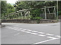
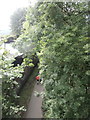
Tubular footbridge at the edge of Bedwlwyn Road, Hengoed
One of two similar footbridges on the west side of Bedwlwyn Road.
Image: © Jaggery
Taken: 23 Aug 2019
0.08 miles
8
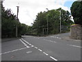
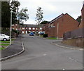
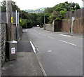
Crossroads in Hengoed
Viewed from Hengoed Road. Bedwlwyn Road is ahead, Park Road on the left, Graig Road on the right.
Image: © Jaggery
Taken: 23 Aug 2019
0.08 miles
9
Dog litter bin, Hengoed Road, Hengoed
Bilingual text on the bin shows that DOG LITTER is SBWRIEL CŴN in Welsh.
Image: © Jaggery
Taken: 23 Aug 2019
0.08 miles
10
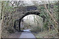
Road bridge over cycle route
Bridge Image over National Cycle Route 47 which here is also part of the Rhymney Valley Ridgeway Walk.
Image: © M J Roscoe
Taken: 24 Mar 2018
0.08 miles