IMAGES TAKEN NEAR TO
Edmund Street, BARGOED, CF81 9RR
Introduction
This page details the photographs taken nearby to Edmund Street, CF81 9RR by members of the Geograph project.
The Geograph project started in 2005 with the aim of publishing, organising and preserving representative images for every square kilometre of Great Britain, Ireland and the Isle of Man.

There are currently over 7.5m images from over14,400 individuals and you can help contribute to the project by visiting https://www.geograph.org.uk
Image Map
Images are licensed for reuse under creativecommons.org/licenses/by-sa/2.0
Notes
- Clicking on the map will re-center to the selected point.
- The higher the marker number, the further away the image location is from the centre of the postcode.
Image Listing (90 Images Found)
Images are licensed for reuse under creativecommons.org/licenses/by-sa/2.0
Image
Details
Distance
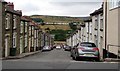
1
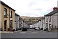
A view down Edmund Street, Pontlottyn
Viewed from the A469 Southend Terrace. A Global Express Parcels van is making a delivery.
Image: © Jaggery
Taken: 19 Apr 2013
0.03 miles
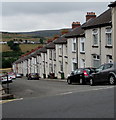
2
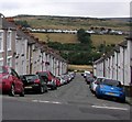
Down Edmund Street, Pontlottyn
Edmund Street descends from the A469 Southend Terrace to Fairview Terrace and Heol y Waun.
Image: © Jaggery
Taken: 27 Jul 2018
0.03 miles
3

A bench with a view of a fence, Pontlottyn
Located at the edge of Fairview Terrace, opposite Edmund Street. http://www.geograph.org.uk/photo/3420272
Beyond the wonky fence is a railway line and the valley of the Rhymney River.
Image: © Jaggery
Taken: 19 Apr 2013
0.03 miles
4
Mozart Cottages, Pontlottyn
Viewed from the A469 Southend Terrace. I could find no explanation for the unusual name of the three cottages. Perhaps they were built by or for an admirer of Wolfgang Amadeus Mozart.
Image: © Jaggery
Taken: 19 Apr 2013
0.03 miles
5
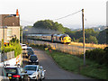
Class 37 near Pontlottyn
Class 37 No. 37025 accelerates away from its stop at Pontlottyn with the 07:24 commuter service from Rhymney to Cardiff Canton. Locomotive No. 37421 is on the rear.
Image: © Gareth James
Taken: 26 Aug 2019
0.04 miles
6
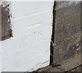
Ordnance Survey Cut Mark
This OS cut mark can be found on No19 Dyffryn Street. It marks a point 247.632m above mean sea level.
Image: © Adrian Dust
Taken: 29 Sep 2018
0.04 miles
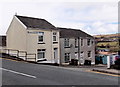
7
Duffryn Street houses, Pontlottyn
Alongside the descent from the A469 Southend Terrace to Fairview Terrace.
Image: © Jaggery
Taken: 27 Jul 2018
0.04 miles
8
Down Duffryn Street, Pontlottyn
Duffryn Street descends from the A469 Southend Terrace to Fairview Terrace.
Image: © Jaggery
Taken: 27 Jul 2018
0.04 miles
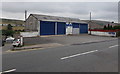
9
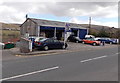
A Pontlottyn garage
Viewed across the A469 Southend Terrace, opposite Mozart Cottages. http://www.geograph.org.uk/photo/3423871
There are four named bays: MoT bay, service bay, valeting bay, tyre bay.
Image: © Jaggery
Taken: 19 Apr 2013
0.04 miles
10
Southend Garage, Pontlottyn
Viewed across the A469 here named Southend Terrace.
Image: © Jaggery
Taken: 27 Jul 2018
0.04 miles