IMAGES TAKEN NEAR TO
Pidwelt Rise, BARGOED, CF81 9QU
Introduction
This page details the photographs taken nearby to Pidwelt Rise, CF81 9QU by members of the Geograph project.
The Geograph project started in 2005 with the aim of publishing, organising and preserving representative images for every square kilometre of Great Britain, Ireland and the Isle of Man.

There are currently over 7.5m images from over14,400 individuals and you can help contribute to the project by visiting https://www.geograph.org.uk
Image Map
Images are licensed for reuse under creativecommons.org/licenses/by-sa/2.0
Notes
- Clicking on the map will re-center to the selected point.
- The higher the marker number, the further away the image location is from the centre of the postcode.
Image Listing (167 Images Found)
Images are licensed for reuse under creativecommons.org/licenses/by-sa/2.0
Image
Details
Distance
1
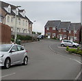
Pidwelt Rise, Pontlottyn
21st century houses (built c2011) in a cul-de-sac on the north side of Fochriw Road.
According to one online source, this is the only Pidwelt anything (Road, Street, Avenue etc) in the UK.
Image: © Jaggery
Taken: 2 Aug 2018
0.02 miles
2
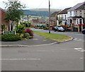
Corner of Pidwelt Rise and Fochriw Road, Pontlottyn
The bilingual name sign shows that Pidwelt Rise is Rhiw Pidwelt in Welsh.
According to one online source, this is the only Pidwelt anything (Road, Street, Avenue etc) in the UK.
Image: © Jaggery
Taken: 2 Aug 2018
0.03 miles
3
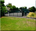
Multi-use sports court in Pontlottyn
On the west side of Farm Road.
Image: © Jaggery
Taken: 2 Aug 2018
0.04 miles
4

Down Fochriw Road, Pontlottyn
Part of the long steep descent from Fochriw to the centre of Pontlottyn.
Image: © Jaggery
Taken: 2 Aug 2018
0.04 miles
5
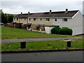
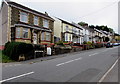
Row of houses, Brynglas, Pontlottyn
One of many rows of houses in Brynglas on the north side of Fochriw Road.
Image: © Jaggery
Taken: 2 Aug 2018
0.05 miles
6
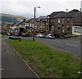
Fochriw Road houses, Pontlottyn
Alongside part of the ascent to Fochriw.
Image: © Jaggery
Taken: 2 Aug 2018
0.05 miles
7
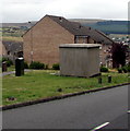
Back of an electricity substation, Fochriw Road, Pontlottyn
The Western Power Distribution electricity substation identifier on the opposite
side of the large cabinet is BRYNHYFRYD S/S 552352. Two telecoms cabinets are on the left.
Image: © Jaggery
Taken: 2 Aug 2018
0.05 miles
9
Fochriw Road houses and cars, Pontlottyn
On the south side of the road. The house on the left is on the corner of Sunny View.
Image: © Jaggery
Taken: 2 Aug 2018
0.06 miles
10
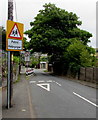
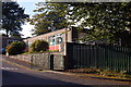
Outdated warning sign, Farm Road, Pontlottyn
The English/Welsh Patrol/Hebryngwr sign remains in place in August 2018 on the approach to the former Pontlottyn Primary School. The school has closed down and the site is for sale. https://www.geograph.org.uk/photo/5865105
Image: © Jaggery
Taken: 2 Aug 2018
0.06 miles