IMAGES TAKEN NEAR TO
Mount Street, BARGOED, CF81 9QA
Introduction
This page details the photographs taken nearby to Mount Street, CF81 9QA by members of the Geograph project.
The Geograph project started in 2005 with the aim of publishing, organising and preserving representative images for every square kilometre of Great Britain, Ireland and the Isle of Man.

There are currently over 7.5m images from over14,400 individuals and you can help contribute to the project by visiting https://www.geograph.org.uk
Image Map
Images are licensed for reuse under creativecommons.org/licenses/by-sa/2.0
Notes
- Clicking on the map will re-center to the selected point.
- The higher the marker number, the further away the image location is from the centre of the postcode.
Image Listing (213 Images Found)
Images are licensed for reuse under creativecommons.org/licenses/by-sa/2.0
Image
Details
Distance
1
High Street, Pontlottyn
Looking towards Farm Road from the dead end of High Street near Merchant Street.
This is not a typical UK High Street. The main commercial street in Pontlottyn is Merchant Street.
Image: © Jaggery
Taken: 27 Jul 2018
0.03 miles
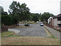
2
West along Farm Road, Pontlottyn
This part of Farm Road leads to Hill Road and Heol Evan Wynne.
Image: © Jaggery
Taken: 2 Aug 2018
0.05 miles
3
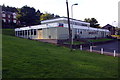
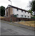
Pontlottyn Community Centre, Snooker Hall and Library
Visited Pontlottyn in April 2012. Building no longer standing not sure if there is any plans to rebuild.
Image: © Melanie Hartshorn
Taken: 30 Sep 2008
0.05 miles
4
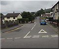
Farm Road, Pontlottyn
South along Farm Road from the Hill Road/Heol Evan Wynne/Legion Court crossroads.
Image: © Jaggery
Taken: 27 Jul 2018
0.06 miles
5
Union Street houses, Pontlottyn
Union Street is a cul-de-sac on the west side of Merchant Street.
Image: © Jaggery
Taken: 27 Jul 2018
0.06 miles
6
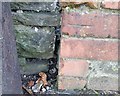
Ordnance Survey Cut Mark
This OS cut mark can be found on the gatepost of Cloverdale, Farm Road. It marks a point 268.447m above mean sea level.
Image: © Adrian Dust
Taken: 29 Sep 2018
0.06 miles
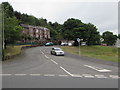
8
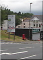
Directions sign on a Pontlottyn corner
Facing the A469 Merchant Street on the corner of Union Street.
Image: © Jaggery
Taken: 27 Jul 2018
0.08 miles
9
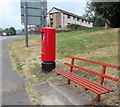
Queen Elizabeth II pillarbox and a brown bench, Merchant Street, Pontlottyn
On the left here. https://www.geograph.org.uk/photo/5856060
Image: © Jaggery
Taken: 27 Jul 2018
0.08 miles
10
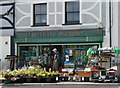
Howard Jones Hardware Stores, Pontlottyn
Above the shop it says "Keys Cut, Pet foods, Calor Gas, Gardening, Hardware, Fireworks".
Image: © Robin Drayton
Taken: 22 Aug 2007
0.08 miles