1
Houses near the edge of a sports ground, Pontlottyn
The houses are on the south side of School Street.
Image: © Jaggery
Taken: 4 May 2019
0.00 miles
2
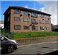
Derelict block of flats in Pontlottyn
Viewed across School Street in May 2019.
Metal sheeting protects lower floor windows.
A top floor window has been damaged.
Image: © Jaggery
Taken: 4 May 2019
0.01 miles
3
School Street through a railway arch, Pontlottyn
Viewed through the southernmost arch of Pontlottyn railway viaduct.
Image: © Jaggery
Taken: 4 May 2019
0.01 miles
4
Pontlottyn Boys & Girls Club
Viewed across River Road. The aims of the club, a registered charity, include promoting the health and well-being of young people in Pontlottyn and surrounding areas through sports, arts, culture and community participation.
Image: © Jaggery
Taken: 19 Apr 2013
0.02 miles
5
The Blast Furnace name sign, Pontlottyn
Colourfully evoking the heat of a blast furnace, the pub sign hangs from a frame on the wall here. http://www.geograph.org.uk/photo/3425360
Image: © Jaggery
Taken: 19 Apr 2013
0.04 miles
6
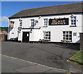
Blast Furnace, Pontlottyn
Pub on the corner of Board Street and River Road. https://www.geograph.org.uk/photo/3425376 to the name sign.
Image: © Jaggery
Taken: 4 May 2019
0.04 miles
7
Entrance to A1 Unique Upholstery, Pontlottyn
Viewed from River Road. The edge of Pontlottyn Boys & Girls Club http://www.geograph.org.uk/photo/3425459 is on the right.
Image: © Jaggery
Taken: 19 Apr 2013
0.04 miles
8
School Street house and railway arch, Pontlottyn
The house is near the southernmost arch of Pontlottyn railway viaduct.
Image: © Jaggery
Taken: 4 May 2019
0.04 miles
9
The Blast Furnace, Pontlottyn
The pub is on the corner of Board Street and River Road.
http://www.geograph.org.uk/photo/3425376 to a view of the pub name sign.
Image: © Jaggery
Taken: 19 Apr 2013
0.04 miles
10
Board Street flats, Pontlottyn
A view from opposite the Blast Furnace. http://www.geograph.org.uk/photo/3425360 Pontlottyn Viaduct http://www.geograph.org.uk/photo/3425141 is in the background.
Image: © Jaggery
Taken: 19 Apr 2013
0.04 miles


