1
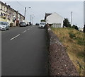
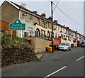
Glenview Terrace, Pentwyn, Darran Valley
This short row of terraced houses is all the houses that remain in this former mining village. For an uphill view, see
Image
Image: © M J Roscoe
Taken: 28 Mar 2018
0.00 miles
2
Former White Horse Inn, Pentwyn
Viewed in July 2018. Robin Drayton's August 2007 photo https://www.geograph.org.uk/photo/537530 shows the inn before conversion to residential in 2012.
Image: © Jaggery
Taken: 11 Jul 2018
0.01 miles
3
White Horse Inn electricity substation, Pentwyn
The cabinet is a Western Power Distribution electricity substation, identifier WHITE HORSE INN S/S 552414. It is located a few metres from this https://www.geograph.org.uk/photo/5838565 house which used to be the White Horse Inn.
Image: © Jaggery
Taken: 11 Jul 2018
0.02 miles
4
Top of a stone wall opposite Glenview Terrace, Pentwyn
The cabinet to the right of the wall is an electricity substation. https://www.geograph.org.uk/photo/5838615
Image: © Jaggery
Taken: 11 Jul 2018
0.02 miles
5
Glenview Terrace, Pentwyn. Fochriw
Pentwyn is situated at the top of the Darran Valley and this is the view as it is approached from the south.
This is the only terrace of housing that remains. All signs of the terraces that housed mine workers in the 19th and for most of the 20th century have disappeared.
Image: © Robin Drayton
Taken: 28 Nov 2012
0.02 miles
6
Warning sign - cattle grid, Pentwyn
On the approach to this grid. https://www.geograph.org.uk/photo/5838601
Horsedrawn vehicles and horse riders can use the gate on the right to bypass the grid.
Image: © Jaggery
Taken: 11 Jul 2018
0.02 miles
7
Glenview Terrace, Pentwyn
Row of houses extending for about 80 metres.
The road near the camera is 400 metres (c1,312 ft) above mean sea level.
Image: © Jaggery
Taken: 11 Jul 2018
0.03 miles
8
Pentwyn - Please Drive Carefully
The sign near the southern end of Glenview Terrace faces the road from Bargoed via Deri.
Pentwyn is part of the Darran Valley community in the County Borough of Caerphilly.
Image: © Jaggery
Taken: 11 Jul 2018
0.03 miles
9
White Horse Inn, Pentwyn
Image: © Robin Drayton
Taken: 22 Aug 2007
0.03 miles
10
Tafarn Mount Pleasant Inn, Pentwyn
Tafarn y Mount Pleasant ym Mhentwyn ger Fochriw.
The Mount Pleasant Inn in Penwtwyn near Fochriw
Image: © Alan Richards
Taken: 9 Sep 2012
0.03 miles


