IMAGES TAKEN NEAR TO
Moores Row, BARGOED, CF81 9JT
Introduction
This page details the photographs taken nearby to Moores Row, CF81 9JT by members of the Geograph project.
The Geograph project started in 2005 with the aim of publishing, organising and preserving representative images for every square kilometre of Great Britain, Ireland and the Isle of Man.

There are currently over 7.5m images from over14,400 individuals and you can help contribute to the project by visiting https://www.geograph.org.uk
Image Map
Images are licensed for reuse under creativecommons.org/licenses/by-sa/2.0
Notes
- Clicking on the map will re-center to the selected point.
- The higher the marker number, the further away the image location is from the centre of the postcode.
Image Listing (106 Images Found)
Images are licensed for reuse under creativecommons.org/licenses/by-sa/2.0
Image
Details
Distance
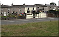
1
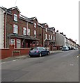
Pleasant View houses, Fochriw
Viewed from the corner of Aelybryn Street.
Image: © Jaggery
Taken: 2 Aug 2018
0.02 miles
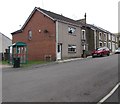
2
Brook Row houses, Fochriw
Row of houses with varying degrees of slope on the roofs.
Image: © Jaggery
Taken: 2 Aug 2018
0.03 miles
3
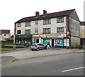
Village Store & Newsagents, Fochriw
In August 2018 the village post office is inside this shop at 1 The Grove, Fochriw.
Image: © Jaggery
Taken: 2 Aug 2018
0.03 miles
4
New dry stone wall at Fochriw
Merthyr Tydfil Borough Council have had for nearly 20 years an enlightened policy of linking the cultural landscape of the post-industrial present to that of the pre-industrial past by constructing new dry stone walls. The ones at Fochriw are on a big scale, and very successful - they are popular with the inhabitants who think it money well spent.
Image: © CHARLES GORDON CLARK
Taken: 5 Aug 2010
0.03 miles
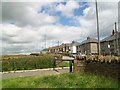
5
The Villas, Aelybryn Street, Fochriw
The sign on the left shows 1 TO 4 THE VILLAS.
Image: © Jaggery
Taken: 2 Aug 2018
0.03 miles
6
Towards the Village Store & Newsagents, Fochriw
Viewed from the bridge over the brook Nant Bargod Rhymni.
Image: © Jaggery
Taken: 2 Aug 2018
0.03 miles
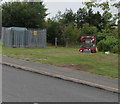
7
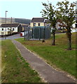
Path past Brook Row electricity substation, Fochriw
A Western Power Distribution electricity substation is inside the locked fenced enclosure.
Its identifier is BROOK ROW FOCHRIW S/S 552355.
Image: © Jaggery
Taken: 2 Aug 2018
0.03 miles
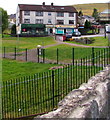
8
War and Colliery Memorial, Fochriw
Officially unveiled on September 25th 2014, the Memorial commemorates the men from the village who lost their lives in wartime and the 141 men and boys who were killed while working at Fochriw Colliery which was in operation from 1863 to 1924.
Image: © Jaggery
Taken: 2 Aug 2018
0.04 miles
9

Faded Rising Sun name sign, Station Terrace, Fochriw
On the left here https://www.geograph.org.uk/photo/5863787 viewed in August 2018.
The former Rising Sun pub has been converted to a house.
Image: © Jaggery
Taken: 2 Aug 2018
0.04 miles
10
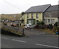
Former Rising Sun pub, Station Terrace, Fochriw
The house on the left used to be the Rising Sun.
A faded Rising Sun name sign https://www.geograph.org.uk/photo/5863789 remains on a pole on the left in August 2018.
An August 2011 Google Earth Street View shows the pub boarded up and for sale.
Image: © Jaggery
Taken: 2 Aug 2018
0.04 miles