IMAGES TAKEN NEAR TO
Plantation Terrace, BARGOED, CF81 9JR
Introduction
This page details the photographs taken nearby to Plantation Terrace, CF81 9JR by members of the Geograph project.
The Geograph project started in 2005 with the aim of publishing, organising and preserving representative images for every square kilometre of Great Britain, Ireland and the Isle of Man.

There are currently over 7.5m images from over14,400 individuals and you can help contribute to the project by visiting https://www.geograph.org.uk
Image Map
Images are licensed for reuse under creativecommons.org/licenses/by-sa/2.0
Notes
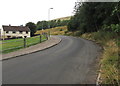
- Clicking on the map will re-center to the selected point.
- The higher the marker number, the further away the image location is from the centre of the postcode.
Image Listing (102 Images Found)
Images are licensed for reuse under creativecommons.org/licenses/by-sa/2.0
Image
Details
Distance
1
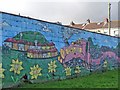
Mural commemorating the former railway, Fochriw
See http://www.geograph.org.uk/photo/3248541 for the complete mural in its context.
Image: © Robin Drayton
Taken: 28 Nov 2012
0.01 miles
2
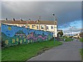
Mural beside a former railway track, Fochriw
This is the view in the opposite direction to that shown here http://www.geograph.org.uk/photo/3248505 .
Image: © Robin Drayton
Taken: 28 Nov 2012
0.02 miles
3
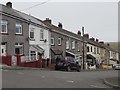
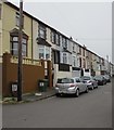
North side of Plantation Terrace, Fochriw
Viewed from the corner of Glyn Terrace.
Image: © Jaggery
Taken: 2 Aug 2018
0.02 miles
4
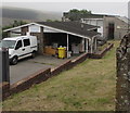
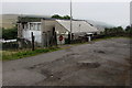
Fochriw Clinic, Fochriw
Medical clinic set back from the corner of Plantation Terrace and Glyn Terrace.
Fochriw Social Club https://www.geograph.org.uk/photo/5861993 is in the background.
Image: © Jaggery
Taken: 2 Aug 2018
0.02 miles
5
Fochriw Social Club
Viewed across Glyn Terrace in Fochriw.
Image: © Jaggery
Taken: 2 Aug 2018
0.03 miles
6
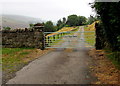
Gate across the access road to Llwyn Iago Farm, Fochriw
At the SE end of Glyn Terrace.
Image: © Jaggery
Taken: 2 Aug 2018
0.04 miles
7
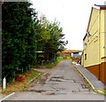
West side of Glyn Terrace, Fochriw
Looking north towards the centre of the village.
Image: © Jaggery
Taken: 2 Aug 2018
0.05 miles
8
Unnamed side road in Fochriw
Ascending from the west side of Glyn Terrace.
Image: © Jaggery
Taken: 2 Aug 2018
0.05 miles
9
Bend in Heol Iago, Fochriw
Part of a bus route - Playground bus stop https://www.geograph.org.uk/photo/5862630 is ahead.
Image: © Jaggery
Taken: 2 Aug 2018
0.05 miles
10
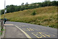
Playground bus stop, Heol Iago, Fochriw
Near this https://www.geograph.org.uk/photo/5862621 playground, the bus stop sign shows Playground and the identifier 5540 AWB 34190. In August 2018 this is a stop on both Stagecoach Route 1 from Merthyr Tydfil to Bargoed and Stagecoach Route 1 from Bargoed to Merthyr Tydfil.
Image: © Jaggery
Taken: 2 Aug 2018
0.05 miles