1
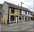
Blue garage in Deri
Viewed across Bailey Street.
Image: © Jaggery
Taken: 12 Jul 2018
0.11 miles
2
Route of footpath to Glyn Derw, Deri
The path, not evident on the ground, runs alongside the fence separating pasture from an enclosure, right. Coed Deri-Newydd is behind the houses.
Image: © M J Roscoe
Taken: 22 Oct 2020
0.13 miles
3
Bronllys, Bailey Street, Deri
Named Bronllys, the house on the left is next door to the Old Club. https://www.geograph.org.uk/photo/5840887
Image: © Jaggery
Taken: 12 Jul 2018
0.14 miles
4
Woodland Rise, Deri
Modern houses viewed from Ogilvie Terrace.
Image: © Jaggery
Taken: 12 Jul 2018
0.15 miles
5
The Old Club, 93 Bailey Street, Deri
Pub near Cwm Darran Country Park.
Image: © Jaggery
Taken: 12 Jul 2018
0.15 miles
6
Footbridge over cycleway, NCR 469, Deri
Restored eastern span of Victorian timber bridge, of pitch pine, over former trackbed of the Cilhaul railway line which served collieries. To the right is the western timber span
Image, both spans resting on a central stone pier.
Image: © M J Roscoe
Taken: 22 Oct 2020
0.15 miles
7
Approach to timber footbridge over former railway lines, Deri
The near span
Image crosses the former Brecon & Merthyr Railway. The far sloping span
Image crosses a former colliery line. The information board gives the history of this rare surviving bridge, unique in Wales.
Image: © M J Roscoe
Taken: 22 Oct 2020
0.15 miles
8
Footbridge over former railway trackbed
Restored western span of rare Victorian timber bridge over route of former Brecon & Methyr Railway. To the right (out of shot) is the other span
Image over a former railway.
Image: © M J Roscoe
Taken: 22 Oct 2020
0.15 miles
9
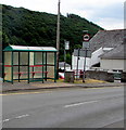
Bus stop and shelter at the northern end of Bailey Street, Deri
This stop is for buses to Bargoed.
Image: © Jaggery
Taken: 12 Jul 2018
0.16 miles
10
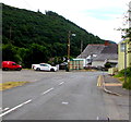
Bailey Street bus stops, Deri
The shelterless stop on the right is for buses to Merthyr Tydfil via Fochriw and Pontlottyn. The stop with a shelter is for buses to Bargoed. The red Royal Mail van is parked while its driver delivers letters and small parcels to nearby addresses.
Image: © Jaggery
Taken: 12 Jul 2018
0.16 miles


