IMAGES TAKEN NEAR TO
Mill Road, BARGOED, CF81 9HG
Introduction
This page details the photographs taken nearby to Mill Road, CF81 9HG by members of the Geograph project.
The Geograph project started in 2005 with the aim of publishing, organising and preserving representative images for every square kilometre of Great Britain, Ireland and the Isle of Man.

There are currently over 7.5m images from over14,400 individuals and you can help contribute to the project by visiting https://www.geograph.org.uk
Image Map
Images are licensed for reuse under creativecommons.org/licenses/by-sa/2.0
Notes
- Clicking on the map will re-center to the selected point.
- The higher the marker number, the further away the image location is from the centre of the postcode.
Image Listing (6 Images Found)
Images are licensed for reuse under creativecommons.org/licenses/by-sa/2.0
Image
Details
Distance
1
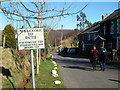
Croeso i Dderi / Welcome to Deri
Cerddwyr yn cyrraedd Deri.
Walkers arriving at Deri (trans. oaks).
Image: © Alan Richards
Taken: 17 Feb 2008
0.09 miles
2
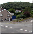
Wooded hillside view in Deri
Viewed across the corner of Glynmarch Street and Bailey Street in July 2018.
Image: © Jaggery
Taken: 12 Jul 2018
0.14 miles
3
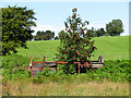
Former railway box van in a field near Deri
Image: © Gareth James
Taken: 7 Aug 2020
0.14 miles
4
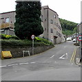
Steep ascent, Mill Road, Deri
Deri Broncos Rugby Football Club clubhouse https://www.geograph.org.uk/photo/5840339 is on the left.
Image: © Jaggery
Taken: 12 Jul 2018
0.23 miles
5

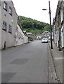
Brecon Terrace, Deri
Ascending from School Street towards Cambrian Street and Watson Row.
Image: © Jaggery
Taken: 12 Jul 2018
0.24 miles
6
Up Mill Road, Deri
Mill Road ascends past Deri Broncos Rugby Football Club club house. https://www.geograph.org.uk/photo/5840339
Image: © Jaggery
Taken: 12 Jul 2018
0.25 miles