IMAGES TAKEN NEAR TO
Mill Road, BARGOED, CF81 9HF
Introduction
This page details the photographs taken nearby to Mill Road, CF81 9HF by members of the Geograph project.
The Geograph project started in 2005 with the aim of publishing, organising and preserving representative images for every square kilometre of Great Britain, Ireland and the Isle of Man.

There are currently over 7.5m images from over14,400 individuals and you can help contribute to the project by visiting https://www.geograph.org.uk
Image Map
Images are licensed for reuse under creativecommons.org/licenses/by-sa/2.0
Notes
- Clicking on the map will re-center to the selected point.
- The higher the marker number, the further away the image location is from the centre of the postcode.
Image Listing (60 Images Found)
Images are licensed for reuse under creativecommons.org/licenses/by-sa/2.0
Image
Details
Distance
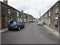
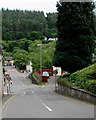
1
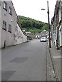
Steep ascent, Mill Road, Deri
Deri Broncos Rugby Football Club clubhouse https://www.geograph.org.uk/photo/5840339 is on the left.
Image: © Jaggery
Taken: 12 Jul 2018
0.02 miles
2
Up Mill Road, Deri
Mill Road ascends past Deri Broncos Rugby Football Club club house. https://www.geograph.org.uk/photo/5840339
Image: © Jaggery
Taken: 12 Jul 2018
0.03 miles
3

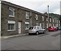
Brecon Terrace, Deri
Ascending from School Street towards Cambrian Street and Watson Row.
Image: © Jaggery
Taken: 12 Jul 2018
0.03 miles
4
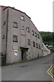
Deri Broncos Rugby Football Club club house, Deri
Viewed across Mill Road in July 2018. A notice near the entrance
shows that the Broncos were WRU National League 3 East Champions
in the 2017-2018 season. WRU = Welsh Rugby Union.
The building was originally Deri Workmen's Hall & Institute
which opened in March 1924.
Image: © Jaggery
Taken: 12 Jul 2018
0.04 miles
5
Jenkins Row leading to Ysgwyddgwyn, Deri
Viewed from the corner of Bailey Street. The houses in the background are in the part of Deri named Ysgwyddgwyn. Ysgwyddgwyn is the original name of the village of Deri. The village name was changed in the 19th century because many incomers to the village (for work in the colliery) could not pronounce Ysgwyddgwyn.
Image: © Jaggery
Taken: 12 Jul 2018
0.05 miles
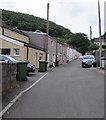
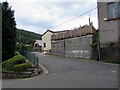
6
West side of School Street, Deri
Houses between Brecon Terrace and Mill Road.
Image: © Jaggery
Taken: 12 Jul 2018
0.06 miles
7
Junction of School Street and Mill Road, Deri
School Street viewed across Mill Road.
Image: © Jaggery
Taken: 12 Jul 2018
0.06 miles
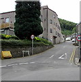
8
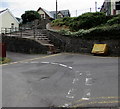
Yellow grit box, Mill Road, Deri
Alongside a 90 degree bend in the main road. Wide steps lead up to School Street.
Image: © Jaggery
Taken: 12 Jul 2018
0.06 miles
9
NNW along School Street, Deri
Looking to the north northwest towards Mill Road from near St Peter's Church. https://www.geograph.org.uk/photo/5840365
Image: © Jaggery
Taken: 12 Jul 2018
0.07 miles
10
Steep descent in Deri
Mill Road descends towards the Bailey Street junction.
Image: © Jaggery
Taken: 12 Jul 2018
0.07 miles