1
Brecon Terrace, Deri
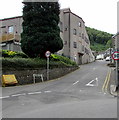
Ascending from School Street towards Cambrian Street and Watson Row.
Image: © Jaggery
Taken: 12 Jul 2018
0.01 miles
2
Steep ascent, Mill Road, Deri
Deri Broncos Rugby Football Club clubhouse https://www.geograph.org.uk/photo/5840339 is on the left.
Image: © Jaggery
Taken: 12 Jul 2018
0.02 miles
3
Up Mill Road, Deri
Mill Road ascends past Deri Broncos Rugby Football Club club house. https://www.geograph.org.uk/photo/5840339
Image: © Jaggery
Taken: 12 Jul 2018
0.02 miles
4
Deri Broncos Rugby Football Club club house, Deri
Viewed across Mill Road in July 2018. A notice near the entrance
shows that the Broncos were WRU National League 3 East Champions
in the 2017-2018 season. WRU = Welsh Rugby Union.
The building was originally Deri Workmen's Hall & Institute
which opened in March 1924.
Image: © Jaggery
Taken: 12 Jul 2018
0.03 miles
5
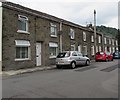
West side of School Street, Deri
Houses between Brecon Terrace and Mill Road.
Image: © Jaggery
Taken: 12 Jul 2018
0.04 miles
6
Junction of School Street and Mill Road, Deri
School Street viewed across Mill Road.
Image: © Jaggery
Taken: 12 Jul 2018
0.04 miles
7
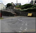
Yellow grit box, Mill Road, Deri
Alongside a 90 degree bend in the main road. Wide steps lead up to School Street.
Image: © Jaggery
Taken: 12 Jul 2018
0.04 miles
8
NNW along School Street, Deri
Looking to the north northwest towards Mill Road from near St Peter's Church. https://www.geograph.org.uk/photo/5840365
Image: © Jaggery
Taken: 12 Jul 2018
0.05 miles
9
Black bench at a bend in School Street, Deri
Viewed from the corner of Mill Road. Double yellow lines on
both sides of School Street indicate no parking at any time.
Image: © Jaggery
Taken: 12 Jul 2018
0.05 miles
10
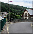
Steep descent in Deri
Mill Road descends towards the Bailey Street junction.
Image: © Jaggery
Taken: 12 Jul 2018
0.05 miles


