1
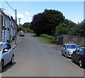
Rural-looking Factory Road, Bargoed
Viewed from the west side http://www.geograph.org.uk/photo/3493086 of Bargoed Viaduct. Looking like a country road, this is the A469 Factory Road.
Image: © Jaggery
Taken: 1 Jun 2013
0.04 miles
2
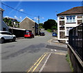
A469 Factory Road near Bristol Terrace
Image: © Colin Pyle
Taken: 21 Apr 2018
0.04 miles
3
Footbridge over disused railway near Bargoed
The footbridge is obviously not the original bridge at this spot, as it is much narrower than the abutments it sits upon. But it must date from the 1960s at latest, because of the smoke deflectors still in situ. The former Brecon & Merthyr railway line is now a foot- and cyclepath here.
Image: © Gareth James
Taken: 29 Dec 2015
0.06 miles
4
Track NW of Usk Road, Bargoed
The track heads towards an area shown on maps in use for smallholdings.
Image: © Jaggery
Taken: 1 Jun 2013
0.09 miles
5
NW end of Usk Road, Bargoed
300 metres NW of its southern end at Church Street, Usk Road ends at a track through an area marked on maps as smallholdings.
Image: © Jaggery
Taken: 1 Jun 2013
0.13 miles
6
Bench, litter bin and signpost at the NW end of Usk Road, Bargoed
The bench has its back to Usk Road. The wooden sign points along a track.
Image: © Jaggery
Taken: 1 Jun 2013
0.14 miles
7
Northwest end of Usk Road, Bargoed
Usk Road northwest of the Hill Street and Graig Terrace junctions.
Image: © Jaggery
Taken: 21 Jun 2018
0.14 miles
8
Towards the northwest end of Usk Road, Bargoed
Looking past the Graig Terrace junction https://www.geograph.org.uk/photo/5822541 on the right.
Image: © Jaggery
Taken: 21 Jun 2018
0.15 miles
9
Lay-by, A469, just north of Bargoed
Image: © John Lord
Taken: 6 Feb 2009
0.15 miles
10
Across the Rhymney valley, Bargoed
A view from this http://www.geograph.org.uk/photo/3492906 track.
Image: © Jaggery
Taken: 1 Jun 2013
0.15 miles


