IMAGES TAKEN NEAR TO
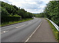
West View Villas, BARGOED, CF81 9ER
Introduction
This page details the photographs taken nearby to West View Villas, CF81 9ER by members of the Geograph project.
The Geograph project started in 2005 with the aim of publishing, organising and preserving representative images for every square kilometre of Great Britain, Ireland and the Isle of Man.

There are currently over 7.5m images from over14,400 individuals and you can help contribute to the project by visiting https://www.geograph.org.uk
Image Map
Images are licensed for reuse under creativecommons.org/licenses/by-sa/2.0
Notes
- Clicking on the map will re-center to the selected point.
- The higher the marker number, the further away the image location is from the centre of the postcode.
Image Listing (317 Images Found)
Images are licensed for reuse under creativecommons.org/licenses/by-sa/2.0
Image
Details
Distance
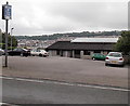
1
Down Angel Way, Aberbargoed
Angel Way descends from Aberbargoed towards Bargoed.
Image: © Jaggery
Taken: 5 Jun 2019
0.04 miles
2
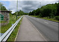
Into Aberbargoed
The road from the A469 in Bargoed to the A4049 in Aberbargoed passes the Aberbargoed boundary sign. https://www.geograph.org.uk/photo/6175149
Image: © Jaggery
Taken: 5 Jun 2019
0.04 miles
3
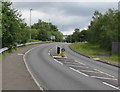
Pedestrian refuge in Angel Way, Aberbargoed
On the ascent from Bargoed to Aberbargoed.
Image: © Jaggery
Taken: 5 Jun 2019
0.05 miles
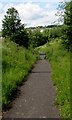
4
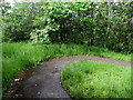
Bend in a path through Bargoed Woodland Park
This part of the park is near Angel Way in Aberbargoed.
Image: © Jaggery
Taken: 5 Jun 2019
0.05 miles
5
The Balfour Club, Aberbargoed
Set back 45 metres from the west side of Commercial Street.
The club was previously named Arthur Balfour Conservative Club.
Image: © Jaggery
Taken: 4 Jul 2013
0.07 miles
6
Inwardly-sloping barrier across a path in Aberbargoed
The metal barrier prevents vehicular misuse of the path below Angel Way.
The edge of Bargoed Woodland Park is on the right.
Image: © Jaggery
Taken: 5 Jun 2019
0.07 miles
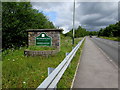
7
New Tredegar and Blackwood directions sign, Aberbargoed
Alongside Angel Way on the approach to the A4049 junction.
The sign also shows the Welsh names for the two locations.
Image: © Jaggery
Taken: 5 Jun 2019
0.08 miles
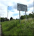
8
Aberbargoed - Please drive carefully
The sign faces the road connecting the A469 in Bargoed with the A4049 in Aberbargoed.
Aberbargoed is Aberbargod in Welsh.
Image: © Jaggery
Taken: 5 Jun 2019
0.08 miles
9
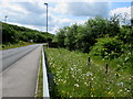
Roadside flowers, Angel Way, Aberbargoed
Alongside the road descending from Aberbargoed to Bargoed viewed in June 2019.
Image: © Jaggery
Taken: 5 Jun 2019
0.08 miles
10
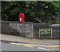
Queen Elizabeth II postbox on an Aberbargoed corner
Located here https://www.geograph.org.uk/photo/6174295 on the Commercial Street side of the Cwrt-Coch Street corner.
Image: © Jaggery
Taken: 5 Jun 2019
0.09 miles