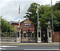
1
Rubble on the site of a demolished hospital, Aberbargoed
Viewed from Pant Street. See http://www.geograph.org.uk/photo/3496414 for another view and details.
Image: © Jaggery
Taken: 1 Jun 2013
0.00 miles
2
Site of a demolished hospital, Aberbargoed
Viewed from Pant Street. The name sign remains as a reminder that this was Aberbargoed & District Hospital, demolished after closure in November 2010. The hospital, run by Aneurin Bevan Health Board, was more than 100 years old. No longer able to provide modern technology facilities, it was the first hosptital in Caerphilly County Borough to close ahead of the opening of the new 255-bed Ysbyty Ystrad Fawr, which at the time was being built in Ystrad Mynach.
The demolished hospital had 22 beds which were mostly used for elderly and frail patients waiting to return home or transfer to a care home. It was also the home base for the district nursing team, the community mental health team, school nurses and a community paediatric nurse.
Image: © Jaggery
Taken: 1 Jun 2013
0.01 miles
3
Steps from Pant Street to Neuaddwen Street Aberbargoed
The steps lead from the corner of the clinic http://www.geograph.org.uk/photo/3496442 to a path at the rear of houses in Neuaddwen Street.
Image: © Jaggery
Taken: 1 Jun 2013
0.04 miles
4
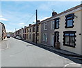
Neuaddwen Street Aberbargoed
Viewed from the Bedwellty Road end looking towards Yew Street.
Image: © Jaggery
Taken: 1 Jun 2013
0.04 miles
5
Aberbargoed Library
Part of Caerphilly County Borough Council's library service, the library in Pant Street
reopened in May 2013 after a £90,000 refurbishment and modernisation.
Aberbargoed Clinic http://www.geograph.org.uk/photo/3496442 is on the right.
Image: © Jaggery
Taken: 1 Jun 2013
0.04 miles
6
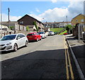
Up Pant Street, Aberbargoed
Pant Street ascends from Commercial Street.
Image: © Jaggery
Taken: 5 Jun 2019
0.04 miles
7
Hills Community Church, Aberbargoed
The church is set back 20 metres from the Commercial Street roadway.
Image: © Jaggery
Taken: 4 Jul 2013
0.05 miles
8
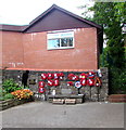
Wreaths on an Aberbargoed War Memorial wall
Aberbargoed War Memorial is set back from Commercial Street, behind these https://www.geograph.org.uk/photo/3541224 gates.
Image: © Jaggery
Taken: 5 Jun 2019
0.05 miles
9
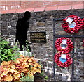
Soldier silhouette in Aberbargoed War Memorial
On the left here. https://www.geograph.org.uk/photo/6258092 The plaque alongside the silhouette records
"In Memory of those Men and Women of Aberbargoed Who served their country in the conflicts of the 20th century. Unveiled and donated by Councillor Alan Higgs Mayor of Bargoed Town Council on 17.4.2019"
Image: © Jaggery
Taken: 5 Jun 2019
0.05 miles
10
War Memorial Gates, Aberbargoed
On the east side of Commercial Street, near the junction with the A469 link road. The War Memorial Gates were erected "In Glorious Memory of Those who fell in the Great War 1914-1918".
The War Memorial Gates bear a plaque, added by the Royal British Legion in 2002, commemorating Glyndwr Michael (1909-1943), a native of Aberbargoed. After his death, he was The Man Who Never Was, a strategy which played a major part in the course of World War II. His corpse, disguised as a Royal Marines officer, was put into the Mediterranean with a briefcase containing documents which convinced the Germans that the Allies planned to attack Greece in the summer of 1943. The real target was Italy.
Image: © Jaggery
Taken: 4 Jul 2013
0.05 miles


