IMAGES TAKEN NEAR TO
Quarry Row, BARGOED, CF81 9AH
Introduction
This page details the photographs taken nearby to Quarry Row, CF81 9AH by members of the Geograph project.
The Geograph project started in 2005 with the aim of publishing, organising and preserving representative images for every square kilometre of Great Britain, Ireland and the Isle of Man.

There are currently over 7.5m images from over14,400 individuals and you can help contribute to the project by visiting https://www.geograph.org.uk
Image Map
Images are licensed for reuse under creativecommons.org/licenses/by-sa/2.0
Notes
- Clicking on the map will re-center to the selected point.
- The higher the marker number, the further away the image location is from the centre of the postcode.
Image Listing (233 Images Found)
Images are licensed for reuse under creativecommons.org/licenses/by-sa/2.0
Image
Details
Distance
1
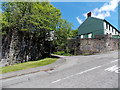
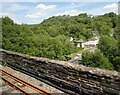
Remains of a railway bridge, Aberbargoed
Viewed across Bedwellty Road towards the house that was formerly the Travellers' Rest inn. http://www.geograph.org.uk/photo/3495361
A railway used to cross the road here, about 150 metres from Aberbargoed railway station, where passenger services ended in 1962. The lane between the masonry is Quarry Row.
Image: © Jaggery
Taken: 1 Jun 2013
0.02 miles
2
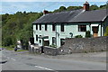
Former Travellers' Rest inn, Aberbargoed
Viewed across Bedwellty Road. Though overpainted, the name of the former inn, now a private residence, can be seen between two satellite dishes.
Image: © Jaggery
Taken: 1 Jun 2013
0.02 miles
3
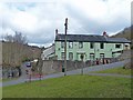
Traveller's Rest, Bedwellty Road, Aberbargoed
A former inn on the old road that connected Bargoed with Aberbargoed.
The name has been painted over but is clearly readable above the front porch.
To the left hand side is the abutment of a former railway bridge that carried a branch of the Brecon & Merthyr railway that ran up the eastern side of the Rhymney Valley as far as Rhymney. Just beyond was the site of Aberbargoed station.
National Cycle Route 468 follows the route of the railway northwards to New Tredegar and Abertysswg.
Image: © Robin Drayton
Taken: 13 Mar 2013
0.02 miles
4
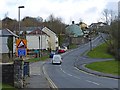
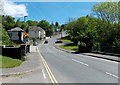
Bedwellty Road, Aberbargoed
This is the road that crosses the Rhymney Valley and until recent years was the only connection between Bargoed and Aberbargoed.
For a view looking down this road see http://www.geograph.org.uk/photo/3370762
Image: © Robin Drayton
Taken: 13 Mar 2013
0.03 miles
5
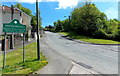
Western boundary of Aberbargoed
Viewed along Bedwellty Road in the Rhymney valley, Bargoed.
Most of the village of Aberbargoed is at the top of the 20% (1 in 5) gradient ahead.
Image: © Jaggery
Taken: 1 Jun 2013
0.03 miles
7
Bedwellty Road crosses the Rhymney, Bargoed
The masonry and dark green railings are at the sides of the road bridge over the river.
Ahead is a very steep ascent http://www.geograph.org.uk/photo/3495212 to Aberbargoed.
Image: © Jaggery
Taken: 1 Jun 2013
0.04 miles
8
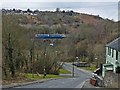
Train crossing Bargoed Viaduct
The train is an Arriva Rhymney to Cardiff service.
For a closer view of the viaduct from the far side see http://www.geograph.org.uk/photo/3370655 .
Image: © Robin Drayton
Taken: 13 Mar 2013
0.04 miles
9
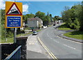
Very steep ascent ahead from Bargoed to Aberbargoed
A view along Bedwellty Road from the bridge over the River Rhymney.
The sign shows a 20% (1 in 5) gradient http://www.geograph.org.uk/photo/3495212 ahead, unsuitable for heavy goods vehicles.
Image: © Jaggery
Taken: 1 Jun 2013
0.05 miles
10
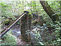
Derelict aqueduct over the Rhymney River in Bargoed
Image: © Gareth James
Taken: 30 Aug 2019
0.05 miles