IMAGES TAKEN NEAR TO
Cwmsyfiog Road, BARGOED, CF81 9AD
Introduction
This page details the photographs taken nearby to Cwmsyfiog Road, CF81 9AD by members of the Geograph project.
The Geograph project started in 2005 with the aim of publishing, organising and preserving representative images for every square kilometre of Great Britain, Ireland and the Isle of Man.

There are currently over 7.5m images from over14,400 individuals and you can help contribute to the project by visiting https://www.geograph.org.uk
Image Map
Images are licensed for reuse under creativecommons.org/licenses/by-sa/2.0
Notes
- Clicking on the map will re-center to the selected point.
- The higher the marker number, the further away the image location is from the centre of the postcode.
Image Listing (138 Images Found)
Images are licensed for reuse under creativecommons.org/licenses/by-sa/2.0
Image
Details
Distance
1
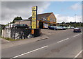
Duffryn Garage, Aberbargoed
Located alongside Cwmsyfiog Road.
Image: © Jaggery
Taken: 4 Jul 2013
0.01 miles
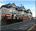
2
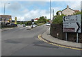
Major road junction in Aberbargoed
Commercial Street is behind the camera. Bedwellty Road runs from left to right across the bottom of the view. Ahead, Cwm Road is on the right. Cwmsyfiog Road is on the left.
Image: © Jaggery
Taken: 4 Jul 2013
0.02 miles
3
Cwm Road, Aberbargoed
Cwm Road climbs away from crossroads, towards Commin Road.
Image: © Jaggery
Taken: 4 Jul 2013
0.03 miles
4
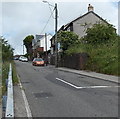
Houses on the north side of Bedwellty Road, Aberbargoed
Bedwellty Road ascends from the valley of the River Rhymney towards the centre of
Aberbargoed. A sign http://www.geograph.org.uk/photo/3495159 at the foot of the hill shows a 20% (1 in 5) gradient.
Image: © Jaggery
Taken: 1 Jun 2013
0.03 miles
5
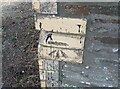
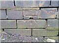
Ordnance Survey Cut Mark
This OS cut mark can be found on the wall junction, SE side of Commin Road. It marks a point 229.959m above mean sea level.
Image: © Adrian Dust
Taken: 12 Feb 2021
0.03 miles
6
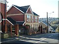
Former Police Station, Aberbargoed
Dated 1909, it is now a residential property.
Image: © Robin Drayton
Taken: 12 Nov 2008
0.04 miles
7
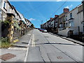
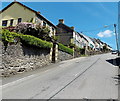
Bedwellty Road climbs away from Chapel Street, Aberbargoed
Bedwellty Road ascends eastwards towards Commercial Street.
Image: © Jaggery
Taken: 1 Jun 2013
0.04 miles
8
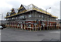
Scaffolding on Blaen-y-Cwm Aberbargoed
Blaen-y-Cwm, on the corner of Commercial Street and Bedwellty Road, contains 30 flats.
Image: © Jaggery
Taken: 4 Jul 2013
0.05 miles
9
Blaen-y-cwm flats, Aberbargoed
The A4049 Commercial Street side of flats on the corner of Bedwellty Road.
Image: © Jaggery
Taken: 5 Jun 2019
0.05 miles
10
Ordnance Survey Cut Mark
This OS cut mark can be found on the wall of No16 Bedwellty Road. It marks a point 202.683m above mean sea level.
Image: © Adrian Dust
Taken: 12 Feb 2021
0.06 miles