IMAGES TAKEN NEAR TO
Baldwin Street, BARGOED, CF81 8UF
Introduction
This page details the photographs taken nearby to Baldwin Street, CF81 8UF by members of the Geograph project.
The Geograph project started in 2005 with the aim of publishing, organising and preserving representative images for every square kilometre of Great Britain, Ireland and the Isle of Man.

There are currently over 7.5m images from over14,400 individuals and you can help contribute to the project by visiting https://www.geograph.org.uk
Image Map
Images are licensed for reuse under creativecommons.org/licenses/by-sa/2.0
Notes
- Clicking on the map will re-center to the selected point.
- The higher the marker number, the further away the image location is from the centre of the postcode.
Image Listing (222 Images Found)
Images are licensed for reuse under creativecommons.org/licenses/by-sa/2.0
Image
Details
Distance
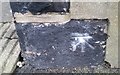
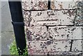
1
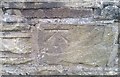
Ordnance Survey Cut Mark
This OS cut mark can be found on the wall of No13 Baldwin Street. It marks a point 227.990m above mean sea level.
Image: © Adrian Dust
Taken: 31 Aug 2019
0.02 miles
2
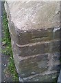
Ordnance Survey Cut Mark
This OS cut mark can be found on the wall of the old vicarage, Moorland Road. It marks a point 239.140m above mean sea level.
Image: © Adrian Dust
Taken: 31 Aug 2019
0.07 miles
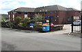
3
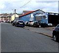
Park Road Garage, Bargoed
The Ruth Street side of the garage on the corner of Park Road.
Image: © Jaggery
Taken: 25 Apr 2018
0.09 miles
4
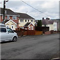
Houses near the western end of West Street, Bargoed
Viewed from the corner of Vicarage Lane. The houses are opposite Bryntirion Surgery. https://www.geograph.org.uk/photo/5764804
Image: © Jaggery
Taken: 25 Apr 2018
0.10 miles
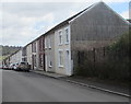
5
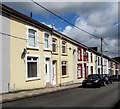
Houses on the south side of West Street, Bargoed
West Street descends towards Ruth Street.
Image: © Jaggery
Taken: 25 Apr 2018
0.11 miles
7
Ordnance Survey Cut Mark
This OS cut mark can be found on No14 Gwladys Avenue. It marks a point 232.812m above mean sea level.
Image: © Adrian Dust
Taken: 31 Aug 2019
0.11 miles
8
Bryntirion Surgery and Boots Pharmacy, Bargoed
Viewed across West Street.
Image: © Jaggery
Taken: 25 Apr 2018
0.11 miles
9
Ordnance Survey Cut Mark
This OS cut mark can be found on No30 West Street. It marks a point 220.520m above mean sea level.
Image: © Adrian Dust
Taken: 31 Aug 2019
0.12 miles
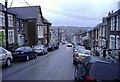
10
Row of houses on the south side of West Street, Bargoed
West Street descends towards Ruth Street.
Image: © Jaggery
Taken: 25 Apr 2018
0.12 miles