IMAGES TAKEN NEAR TO
Hanbury Road, BARGOED, CF81 8QU
Introduction
This page details the photographs taken nearby to Hanbury Road, CF81 8QU by members of the Geograph project.
The Geograph project started in 2005 with the aim of publishing, organising and preserving representative images for every square kilometre of Great Britain, Ireland and the Isle of Man.

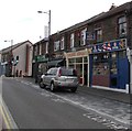
There are currently over 7.5m images from over14,400 individuals and you can help contribute to the project by visiting https://www.geograph.org.uk
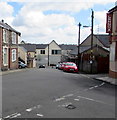
Image Map
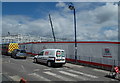
Images are licensed for reuse under creativecommons.org/licenses/by-sa/2.0
Notes
- Clicking on the map will re-center to the selected point.
- The higher the marker number, the further away the image location is from the centre of the postcode.
Image Listing (310 Images Found)
Images are licensed for reuse under creativecommons.org/licenses/by-sa/2.0
Image
Details
Distance
1
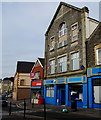
Bargoed Citizens Advice Bureau
The Hanbury Road office is near the corner of West Street.
Image: © Jaggery
Taken: 11 Jul 2018
0.00 miles
2
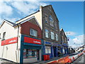
Ladbrokes and Citizens Advice Bureau, Bargoed
The Ladbrokes betting shop is on the corner of Hanbury Road and West Street.
Next door, the Citizens Advice Bureau is in what looks like a former chapel building.
Image: © Jaggery
Taken: 15 May 2013
0.01 miles
3
Poundworld Bargoed
Discount store in Units 1 & 2, Lowry Plaza, Hanbury Road, Bargoed.
Image: © Jaggery
Taken: 25 Apr 2018
0.01 miles
4
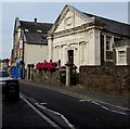
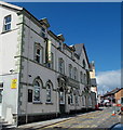
Bargoed Town Hall
The Grade II listed former Police Court erected in 1911 has been the home of Bargoed Town Council since 2014.
Image: © Jaggery
Taken: 11 Jul 2018
0.01 miles
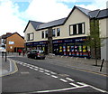
5

Row of shops, Hanbury Road, Bargoed
Viewed from the corner of Cross Street. Nearest the camera are
The Barber Shop, Valley Heating and the Wood Burning Stove Centre.
Image: © Jaggery
Taken: 15 May 2013
0.01 miles
6
USA Fried Chicken in Bargoed
Town centre takeaway in Hanbury Road.
Image: © Jaggery
Taken: 11 Jul 2018
0.01 miles
7
Hanbury Road perimeter fence of The Plateau, Bargoed
The Plateau http://www.geograph.org.uk/photo/3464409 is a major retail development in Bargoed town centre.
Image: © Jaggery
Taken: 15 May 2013
0.01 miles
8
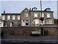
Grade II listed Bargoed Police Station
Dated 1904, the Edwardian building is part of the Gwent Police force. Grade II listed in 2002 as an early 20th century civic building of strong architectural character in a prominent location.
Image: © Jaggery
Taken: 11 Jul 2018
0.02 miles
9
Lowan's Irish Bar, Bargoed
The Hanbury Road building in the town centre was formerly The Hanbury Arms. http://www.geograph.org.uk/photo/1152642
Image: © Jaggery
Taken: 15 May 2013
0.02 miles
10
Southeast end of West Street, Bargoed
West Street descends towards Hanbury Road. Club Lennox https://www.geograph.org.uk/photo/5751312 is on the right.
Image: © Jaggery
Taken: 25 Apr 2018
0.02 miles