IMAGES TAKEN NEAR TO
John Street, BARGOED, CF81 8PG
Introduction
This page details the photographs taken nearby to John Street, CF81 8PG by members of the Geograph project.
The Geograph project started in 2005 with the aim of publishing, organising and preserving representative images for every square kilometre of Great Britain, Ireland and the Isle of Man.

There are currently over 7.5m images from over14,400 individuals and you can help contribute to the project by visiting https://www.geograph.org.uk
Image Map
Images are licensed for reuse under creativecommons.org/licenses/by-sa/2.0
Notes
- Clicking on the map will re-center to the selected point.
- The higher the marker number, the further away the image location is from the centre of the postcode.
Image Listing (170 Images Found)
Images are licensed for reuse under creativecommons.org/licenses/by-sa/2.0
Image
Details
Distance
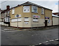
1
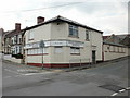
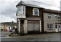
Bargoed Labour Club & Institute
Located at 1a Upper Wood Street, on the corner of Ruth Street.
Image: © Jaggery
Taken: 7 May 2010
0.01 miles
2
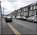
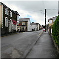
On-street parking, Ruth Street, Bargoed
Looking south along Ruth Street from near the Wood Street/Upper Wood Street intersection.
Image: © Jaggery
Taken: 25 Apr 2018
0.03 miles
3
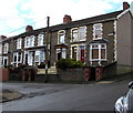
Houses at the northern end of John Street, Bargoed
Viewed across Upper Wood Street.
Image: © Jaggery
Taken: 25 Apr 2018
0.03 miles
4
Knowledge is Strength, Bargoed
Viewed across Park Crescent. The Welsh inscription https://www.geograph.org.uk/photo/6135650 on the tablet on the wall
of Park Primary School is Gwybodaeth sydd Nerth (Knowledge is Strength)
Image: © Jaggery
Taken: 25 Apr 2018
0.05 miles
5
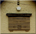
Gwybodaeth sydd Nerth, Bargoed
Meaning Knowledge is Strength, the Welsh inscription dated 1922 is on Park Primary School here. https://www.geograph.org.uk/photo/6135649
Image: © Jaggery
Taken: 25 Apr 2018
0.05 miles
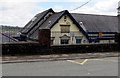
6
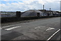
Derelict former shop on a Bargoed corner
On the corner of Ruth Street and Wood Street viewed in April 2018. This corner
has been derelict for many years - an August 2011 Google Earth Street View shows a similar scene.
Image: © Jaggery
Taken: 25 Apr 2018
0.05 miles
7
From Wood Street to Upper Wood Street, Bargoed
The STOP sign is on the corner of the Ruth Street intersection where Wood Street on the camera side becomes Upper Wood Street on the ascent towards Bargoed Park.
Image: © Jaggery
Taken: 25 Apr 2018
0.05 miles
8
Park Crescent speed bumps, Bargoed
On the approach to Park Primary School.
Image: © Jaggery
Taken: 25 Apr 2018
0.06 miles
9
Bargoed Labour Club
On the corner of Upper Wood Street and Ruth Street viewed in April 2018.
The club name and the exterior of the building have changed since this https://www.geograph.org.uk/photo/1848281 May 2010 photo.
Image: © Jaggery
Taken: 25 Apr 2018
0.06 miles
10
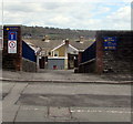
Entrance to Park Primary School, Bargoed
From Park Crescent. Maximum speed 5 mph. This way for the staff car park and for deliveries.
Image: © Jaggery
Taken: 25 Apr 2018
0.06 miles