IMAGES TAKEN NEAR TO
St. Mary Street, BARGOED, CF81 8NG
Introduction
This page details the photographs taken nearby to St. Mary Street, CF81 8NG by members of the Geograph project.
The Geograph project started in 2005 with the aim of publishing, organising and preserving representative images for every square kilometre of Great Britain, Ireland and the Isle of Man.

There are currently over 7.5m images from over14,400 individuals and you can help contribute to the project by visiting https://www.geograph.org.uk
Image Map
Images are licensed for reuse under creativecommons.org/licenses/by-sa/2.0
Notes
- Clicking on the map will re-center to the selected point.
- The higher the marker number, the further away the image location is from the centre of the postcode.
Image Listing (122 Images Found)
Images are licensed for reuse under creativecommons.org/licenses/by-sa/2.0
Image
Details
Distance
1
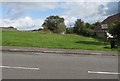
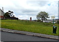
No golf or horse riding on this green, St Mary Street, Gilfach
A prohibition notice https://www.geograph.org.uk/photo/6244019 is on the right.
Image: © Jaggery
Taken: 21 Aug 2019
0.00 miles
2
Prohibition notice, St Mary Street, Gilfach
The Rhymney Valley District Council notice on the right here https://www.geograph.org.uk/photo/6244010 states
WARNING - THE PRACTICE OF GOLF AND HORSE RIDING ARE STRICTLY PROHIBITED IN THIS AREA.
Image: © Jaggery
Taken: 21 Aug 2019
0.01 miles
3
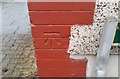
Ordnance Survey Cut Mark
This OS cut mark can be found on No20 Mary Street. It marks a point 205.042m above mean sea level.
Image: © Adrian Dust
Taken: 31 Aug 2019
0.02 miles
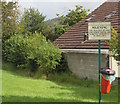
4
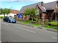
Entrance to St Margaret's Church, Gilfach
From the north side of St Mary Street. St Margaret's Church is in
the Church in Wales Parish of Gelligaer in the Diocese of Llandaff.
https://www.geograph.org.uk/photo/6243852 to the church information board on the right.
Image: © Jaggery
Taken: 21 Aug 2019
0.03 miles
5
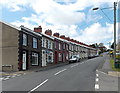
Up St Mary Street, Gilfach
St Mary Street climbs away from St Anne's Crescent on the left and Llys-y-parc on the camera side.
Image: © Jaggery
Taken: 15 May 2013
0.03 miles
6
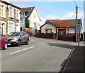
Junction of St Anne Street and St Mary Street, Gilfach
The 20mph speed limit on St Anne Street increases to 30mph at the St Mary Street junction.
Image: © Jaggery
Taken: 21 Aug 2019
0.03 miles
7
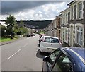
Down St Mary Street, Gilfach
St Mary Street descends towards Cross Street.
Image: © Jaggery
Taken: 21 Aug 2019
0.03 miles
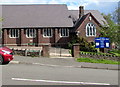
8
St Margaret's Church, St Mary Street, Gilfach
In the Church in Wales Parish of Gelligaer in the Diocese of Llandaff.
Image: © Jaggery
Taken: 21 Aug 2019
0.03 miles
9
No golf or horse riding on this open space, Gilfach
Viewed across St Mary Street. The notice on the right states that the practice
of golf and horse riding are strictly prohibited in this area.
Image: © Jaggery
Taken: 15 May 2013
0.03 miles
10
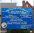
Church board, St Margaret's Gilfach
The board is at the right edge of this http://www.geograph.org.uk/photo/3462216 view.
Image: © Jaggery
Taken: 15 May 2013
0.03 miles