1
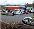
Northern side of Lewis School Pengam
Viewed from the corner of the A469. The school traces its origins to 1729, the year of the founding of a grammar school for boys, Lewis Boys' School. The school has been at this site, near the Gilfach boundary, since 2002.
Image: © Jaggery
Taken: 15 May 2013
0.02 miles
2
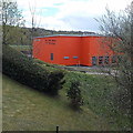
Orange building, Lewis School Pengam
Viewed from the A469. The northernmost school building is the most conspicuous.
Image: © Jaggery
Taken: 15 May 2013
0.02 miles
3
Left turn ahead for Gilfach
Viewed along the A469 between Glan-y-nant and Bargoed.
Image: © Jaggery
Taken: 1 May 2013
0.05 miles
4
Southern boundary of Gilfach
Gilfach is a small village in Caerphilly county borough between Pengam and Bargoed.
Image: © Jaggery
Taken: 1 May 2013
0.09 miles
5
Woodland path, Bargoed Woodland Park
Path going north, parallel with the River Rhymney.
Image: © M J Roscoe
Taken: 16 Mar 2021
0.10 miles
6
Footbridge, Lewis School Pengam
The footbridge over the A469 connects Lewis School Pengam on the right with a path to Glan-y-nant on the left.
Image: © Jaggery
Taken: 1 May 2013
0.10 miles
7
Railway line south of Cardiff Road, Gilfach
Viewed from this http://www.geograph.org.uk/photo/3450334 bridge.
This is the Rhymney Line between Gilfach Fargoed station and Pengam station.
Image: © Jaggery
Taken: 1 May 2013
0.12 miles
8
Footbridge across the River Rhymney
Bargoed Woodland Park / Parc Coetir Bargod.
This is on National Cycle Route 468.
Image: © Robin Drayton
Taken: 23 Aug 2013
0.12 miles
9
Cycle bridge, River Rhymney, Bargoed Woodland Park
Looking upstream at metal bridge
Image carrying NCR 468/footpath.
Image: © M J Roscoe
Taken: 16 Mar 2021
0.12 miles
10
Cycle bridge, River Rhymney, Bargoed Woodland Park
Bridge
Image carrying NCR 468.
Image: © M J Roscoe
Taken: 16 Mar 2021
0.12 miles


