IMAGES TAKEN NEAR TO
The Close, BARGOED, CF81 8JZ
Introduction
This page details the photographs taken nearby to The Close, CF81 8JZ by members of the Geograph project.
The Geograph project started in 2005 with the aim of publishing, organising and preserving representative images for every square kilometre of Great Britain, Ireland and the Isle of Man.

There are currently over 7.5m images from over14,400 individuals and you can help contribute to the project by visiting https://www.geograph.org.uk
Image Map
Images are licensed for reuse under creativecommons.org/licenses/by-sa/2.0
Notes
- Clicking on the map will re-center to the selected point.
- The higher the marker number, the further away the image location is from the centre of the postcode.
Image Listing (138 Images Found)
Images are licensed for reuse under creativecommons.org/licenses/by-sa/2.0
Image
Details
Distance
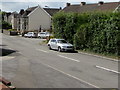
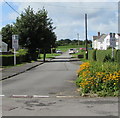
1
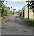
The Close, Gilfach
Cul-de-sac on the north side of The Drive.
Image: © Jaggery
Taken: 17 Aug 2019
0.02 miles
2
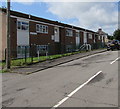
17-24 Vere Place, Gilfach
Flats on the south side of Vere Place on the approach to Vere Street and The Avenue.
Image: © Jaggery
Taken: 17 Aug 2019
0.03 miles
3
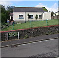
Gilfach O.A.P. Welfare Hall
The name sign records that the Old Age Pensioners' Welfare Hall was established in 1951. If it had been established several decades later, it's likely Senior Citizens would have been used instead of O.A.P.
Image: © Jaggery
Taken: 17 Aug 2019
0.03 miles
4
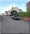
Vere Place, Gilfach
Vere Place ascends towards Vere Street and The Avenue.
Image: © Jaggery
Taken: 17 Aug 2019
0.04 miles
5
Hedges and houses, Gwerthonor Road, Gilfach
Viewed from the corner of Cardiff Road.
Image: © Jaggery
Taken: 17 Aug 2019
0.04 miles
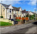
6

Stone semis, Gwerthonor Road, Gilfach
Semi-detached houses on the west side of Gwerthonor Road.
Image: © Jaggery
Taken: 17 Aug 2019
0.04 miles
7
West side of Gwerthonor Road, Gilfach
The house on the left is on the corner of The Drive.
Image: © Jaggery
Taken: 17 Aug 2019
0.04 miles
8
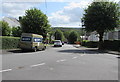
Down The Drive, Gilfach
The Drive descends eastwards towards Gwerthonor Road. The Lewis Crescent junction is on the right.
Image: © Jaggery
Taken: 17 Aug 2019
0.04 miles
9
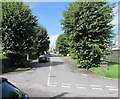
Up a tree-lined road in Gilfach
The Drive ascends away from Gwerthonor Road.
Image: © Jaggery
Taken: 17 Aug 2019
0.04 miles
10
From 20 to 30 on The Avenue, Gilfach
The 20mph speed limit in force near Gilfach Fargoed Primary School increases to 30mph ahead.
Image: © Jaggery
Taken: 17 Aug 2019
0.04 miles