IMAGES TAKEN NEAR TO
CF7 9DT
Introduction
This page details the photographs taken nearby to CF7 9DT by members of the Geograph project.
The Geograph project started in 2005 with the aim of publishing, organising and preserving representative images for every square kilometre of Great Britain, Ireland and the Isle of Man.

There are currently over 7.5m images from over14,400 individuals and you can help contribute to the project by visiting https://www.geograph.org.uk
Image Map
Images are licensed for reuse under creativecommons.org/licenses/by-sa/2.0
Notes
- Clicking on the map will re-center to the selected point.
- The higher the marker number, the further away the image location is from the centre of the postcode.
Image Listing (117 Images Found)
Images are licensed for reuse under creativecommons.org/licenses/by-sa/2.0
Image
Details
Distance
1
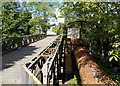
Road bridge and pipe bridge over the Ely, Pontyclun
Station Terrace and a large-bore pipe cross the River Ely. The road bridge's surface is wooden planks. The noise of a vehicle crossing can be heard many metres away. The notice on the meshing above the pipe states that there is no public right of way over this bridge - use it at your own risk.
Maximum weight 7.5 tons. The maximum weight message is repeated on the smaller notice.
Image: © Jaggery
Taken: 5 Jun 2014
0.02 miles
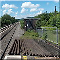
2
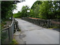
Cowbridge Branch Railway
I believed this was the bridge that the railway used leaving Pontyclun heading for Llanharry.
14/01/2013 Have received information that this bridge was a replacement for an old stone road bridge. The railway bridge was apparently on the right hand side of this bridge.
Image: © Ray Durrant
Taken: 3 Aug 2012
0.03 miles
3
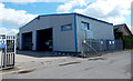
Jordan Civils stone supplies, Pontyclun
Located in Ely Valley Business Park, Station Terrace.
Labelled samples of some of their products are on display alongside a wall.
Image: © Jaggery
Taken: 5 Jun 2014
0.03 miles
4
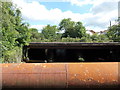
From pipe bridge to railway bridge, Pontyclun
Viewed from here http://www.geograph.org.uk/photo/4026199 looking along the Ely River towards the bridge carrying the South Wales main railway line over the water.
Image: © Jaggery
Taken: 5 Jun 2014
0.03 miles
5
Jolly Jesters in Pontyclun
Children's play centre in Unit 17, Ely Valley Business Park, viewed from the corner of Station Terrace.
Image: © Jaggery
Taken: 5 Jun 2014
0.04 miles
6

Trade Frames Direct, Pontyclun
Premises and van in Ely Valley Business Park, viewed from Station Terrace.
Image: © Jaggery
Taken: 5 Jun 2014
0.04 miles
7
Electricity substation near Pontyclun railway station
Viewed from the NW end of a station platform. The substation is on the right. The railings on the left are at the edge of the bridge carrying the South Wales Main Line over the Ely River.
Image: © Jaggery
Taken: 5 Jun 2014
0.04 miles
8
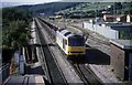
Iron Ore for Llanwern passing Pontyclun
Iron ore from the docks at Port Talbot head east for the blast furnace at Llanwern steel works, to the east of Newport. This view is taken from the re-opened Pontyclun station. The station was known as Llantrisant in the past and was a junction station as can be seen with the lines behind, the station was shut to passengers on the 2 Nov 1964.The station re-opened as Pontyclun on the 28th December 1992. Iron ore trains no longer pass here as the blast furnaces at Llanwern are no more and like so much of the freight traffic of South Wales this traffic is now history.
Image: © roger geach
Taken: 16 Sep 1993
0.05 miles
9
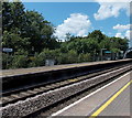
Pontyclun railway station platform
Accessed from Station Terrace, the platform on the far side of the tracks is for arrivals
from Cardiff Central and departures for Llanharan, Bridgend and other points west.
Image: © Jaggery
Taken: 5 Jun 2014
0.06 miles
10
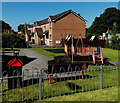
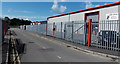
Children's play area near an entrance to Pontyclun railway station
The play area is on the corner of Station Terrace and Heol yr Orsaf.
Image: © Jaggery
Taken: 12 Jun 2014
0.06 miles