IMAGES TAKEN NEAR TO
Talygarn, PONTYCLUN, CF72 9XD
Introduction
This page details the photographs taken nearby to CF72 9XD by members of the Geograph project.
The Geograph project started in 2005 with the aim of publishing, organising and preserving representative images for every square kilometre of Great Britain, Ireland and the Isle of Man.

There are currently over 7.5m images from over14,400 individuals and you can help contribute to the project by visiting https://www.geograph.org.uk
Image Map
Images are licensed for reuse under creativecommons.org/licenses/by-sa/2.0
Notes
- Clicking on the map will re-center to the selected point.
- The higher the marker number, the further away the image location is from the centre of the postcode.
Image Listing (11 Images Found)
Images are licensed for reuse under creativecommons.org/licenses/by-sa/2.0
Image
Details
Distance
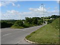
1
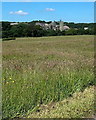
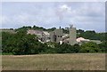
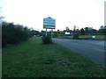
Quarry buildings viewed from Talygarn
Looking towards the Hanson Aggregates Forest Wood Quarry from the A4222 Cowbridge Road.
Image: © Jaggery
Taken: 12 Jun 2014
0.00 miles
3
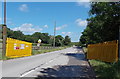
Yellow gates at the entrance road to a quarry near Talygarn
Located on the north side of the A4222 Cowbridge Road near the Vale of Glamorgan/Rhondda Cynon Taf boundary. Ahead is the Hanson Aggregates (Pontyclun) Forest Wood Quarry.
No unauthorised entry beyond the gates. Speed limit 10 mph.
Image: © Jaggery
Taken: 12 Jun 2014
0.17 miles
4
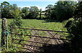
Tyre tracks into a field near Talygarn
The field gate is between the A4222 Cowbridge Road and these yellow gates. http://www.geograph.org.uk/photo/4023852
Image: © Jaggery
Taken: 12 Jun 2014
0.19 miles
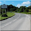
6
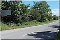
Southern boundary of Rhondda Cynon Taf
The A4222 Cowbridge Road passes from the northern edge of the Vale of Glamorgan
into Rhondda Cynon Taf County Borough. The Talygarn village boundary sign is ahead.
Image: © Jaggery
Taken: 12 Jun 2014
0.20 miles
7
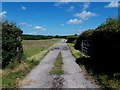
Entrance to Tŷ Newydd Farm, Talygarn
The farm buildings are about 450 metres from the entrance from the A4222 Cowbridge Road.
Image: © Jaggery
Taken: 12 Jun 2014
0.20 miles
8
Talygarn boundary sign
Located alongside the A4222 Cowbridge Road at the southern edge of Rhondda Cynon Taf County Borough - that boundary sign http://www.geograph.org.uk/photo/4023807 is a few metres behind the camera.
Image: © Jaggery
Taken: 12 Jun 2014
0.20 miles
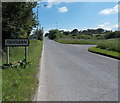
10
Vale of Glamorgan boundary sign near Talygarn
The A4222 Cowbridge Road passes from the southern edge of Rhondda Cynon Taf County Borough
into the Vale of Glamorgan. The smaller sign ahead is a speed camera sign.
Image: © Jaggery
Taken: 12 Jun 2014
0.21 miles