IMAGES TAKEN NEAR TO
Blackthorn Court, PONTYCLUN, CF72 9WU
Introduction
This page details the photographs taken nearby to Blackthorn Court, CF72 9WU by members of the Geograph project.
The Geograph project started in 2005 with the aim of publishing, organising and preserving representative images for every square kilometre of Great Britain, Ireland and the Isle of Man.

There are currently over 7.5m images from over14,400 individuals and you can help contribute to the project by visiting https://www.geograph.org.uk
Image Map
Images are licensed for reuse under creativecommons.org/licenses/by-sa/2.0
Notes
- Clicking on the map will re-center to the selected point.
- The higher the marker number, the further away the image location is from the centre of the postcode.
Image Listing (109 Images Found)
Images are licensed for reuse under creativecommons.org/licenses/by-sa/2.0
Image
Details
Distance
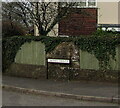
1
Blackthorn Court, Llanharry
Cul-de-sac on the east side of Addison Avenue.
Image: © Jaggery
Taken: 21 Apr 2021
0.01 miles
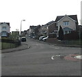
2
Blackthorn Court, Llanharry
Cul-de-sac and private road on the east side of Addison Avenue.
Image: © Jaggery
Taken: 21 Apr 2021
0.03 miles
3
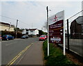
Bilingual school nameboard, Addison Avenue, Llanharry
The board shows that Llanhari Primary School is Ysgol Gynradd Llanhari in Welsh.
The village name is usually spelt Llanharry in English.
Image: © Jaggery
Taken: 21 Apr 2021
0.07 miles
4
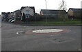
Mini-roundabout, Addison Avenue, Llanharry
At the Blackthorn Court junction.
Image: © Jaggery
Taken: 21 Apr 2021
0.07 miles
5
Welsh-only name sign on a Llanharry corner
The sign on the corner of Addison Avenue shows that the cul-de-sac Carreg Arwyn https://www.geograph.org.uk/photo/6906487 has a Welsh-only name.
Image: © Jaggery
Taken: 21 Apr 2021
0.08 miles
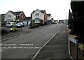
6
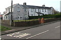
Grey and white houses, Addison Avenue, Llanharry
Southwest of the Aelfryn junction.
Image: © Jaggery
Taken: 21 Apr 2021
0.09 miles
7
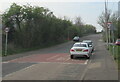
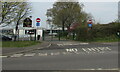
From 20 to 30, Llanharry
Near the SW edge of the village, the 20mph speed limit in force near schools increases to 30mph. In the background, the road crosses a bridge over the M4 motorway.
Image: © Jaggery
Taken: 21 Apr 2021
0.09 miles
8
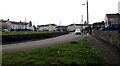
SE along Aelfryn, Llanharry
From the corner of Addison Avenue.
Image: © Jaggery
Taken: 21 Apr 2021
0.10 miles
9
School exit road, Llanharry
From Ysgol Llanhari (a Welsh-medium school for 3-19 year olds) into Addison Avenue.
Image: © Jaggery
Taken: 21 Apr 2021
0.10 miles
10
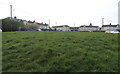
Green in the middle of Aelfryn, Llanharry
Area of grass extending for 80 metres between the two parts of the road name Aelfryn.
Image: © Jaggery
Taken: 21 Apr 2021
0.10 miles