IMAGES TAKEN NEAR TO
Ynysddu, PONTYCLUN, CF72 9UE
Introduction
This page details the photographs taken nearby to Ynysddu, CF72 9UE by members of the Geograph project.
The Geograph project started in 2005 with the aim of publishing, organising and preserving representative images for every square kilometre of Great Britain, Ireland and the Isle of Man.

There are currently over 7.5m images from over14,400 individuals and you can help contribute to the project by visiting https://www.geograph.org.uk
Image Map
Images are licensed for reuse under creativecommons.org/licenses/by-sa/2.0
Notes
- Clicking on the map will re-center to the selected point.
- The higher the marker number, the further away the image location is from the centre of the postcode.
Image Listing (95 Images Found)
Images are licensed for reuse under creativecommons.org/licenses/by-sa/2.0
Image
Details
Distance
1
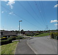
Wires over Ynysddu, Pontyclun
Ynysddu is an area of modern houses west of the Ely River in Pontyclun.
Image: © Jaggery
Taken: 5 Jun 2014
0.04 miles
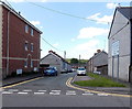
2
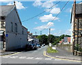
Merthyr Street, Pontyclun
Viewed across the A4222 Llantrisant Road.
At the far end of Merthyr Street is Maelog Close, on a bank of the Ely River.
Image: © Jaggery
Taken: 5 Jun 2014
0.08 miles
3
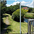
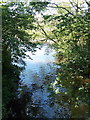
Riverside footpath, Pontyclun
Along a bank of the Ely River from the street named Ynysddu.
Image: © Jaggery
Taken: 5 Jun 2014
0.08 miles
4
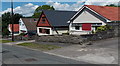
Merthyr Street bungalows, Pontyclun
The Maelog Close junction is a few metres beyond the bungalow on the left.
Image: © Jaggery
Taken: 5 Jun 2014
0.08 miles
5
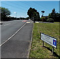
Ynysddu leading to Clos Ynysddu, Pontyclun
From the corner of the A4222, the road ahead crosses the River Ely. Beyond is a large area of modern houses. Although the street names on the sign are in Welsh only, no Welsh equivalent of LEADING TO is shown.
Image: © Jaggery
Taken: 5 Jun 2014
0.09 miles
6
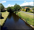
Upstream along the Ely, Pontyclun
The Ely River (Afon Elai in Welsh) flows towards this http://www.geograph.org.uk/photo/4499303 bridge. About 30 metres
behind the bridge, its waters are augmented at the confluence http://www.geograph.org.uk/photo/4499323 with the Afon Clun.
Image: © Jaggery
Taken: 5 Jun 2014
0.09 miles
7
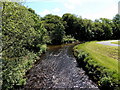
Confluence of the Clun and Ely in Pontyclun
Viewed from here http://www.geograph.org.uk/photo/4499303 looking along the Ely River ( (Afon Elai in Welsh).
The smaller Afon Clun flows in from the left.
Image: © Jaggery
Taken: 5 Jun 2014
0.09 miles
8
Confluence of the Clun and Ely in Pontyclun
Viewed from Llantrisant Road near the fire station. http://www.geograph.org.uk/photo/4017182
The Clun flows into the larger Ely River (Afon Elai in Welsh).
Image: © Jaggery
Taken: 5 Jun 2014
0.09 miles
9
Lewis Street, Pontyclun
Viewed across the A4222 Llantrisant Road looking towards distant houses
in Lon Elai on a bank of the Ely River. Cwrt Bethel http://www.geograph.org.uk/photo/4017348 is on the left.
Image: © Jaggery
Taken: 5 Jun 2014
0.09 miles
10
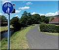
Riverside footpath and cycleway, Pontyclun
From the street named Ynysddu, the route along a bank of the River
Ely heads west towards Coedely (3 miles) and Tonyrefail (5 miles).
Image: © Jaggery
Taken: 5 Jun 2014
0.10 miles