IMAGES TAKEN NEAR TO
Gellifedi Road, PONTYCLUN, CF72 9QG
Introduction
This page details the photographs taken nearby to Gellifedi Road, CF72 9QG by members of the Geograph project.
The Geograph project started in 2005 with the aim of publishing, organising and preserving representative images for every square kilometre of Great Britain, Ireland and the Isle of Man.

There are currently over 7.5m images from over14,400 individuals and you can help contribute to the project by visiting https://www.geograph.org.uk
Image Map
Images are licensed for reuse under creativecommons.org/licenses/by-sa/2.0
Notes
- Clicking on the map will re-center to the selected point.
- The higher the marker number, the further away the image location is from the centre of the postcode.
Image Listing (9 Images Found)
Images are licensed for reuse under creativecommons.org/licenses/by-sa/2.0
Image
Details
Distance
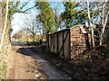
1
Part of Brynna
A convenience store, one of a few in this village.
Image: © Jeremy Bolwell
Taken: 31 Jul 2011
0.12 miles

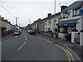
5
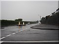
One for the road
View of the road junction at Brynna Road (the main road) and Gellifedi Road / Hillcrest, from where the picture was taken.
Just one more before calling it a day.
Image: © Ian Paterson
Taken: 2 Jun 2008
0.19 miles
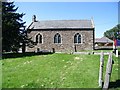
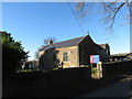
7
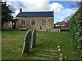
St.Peter's Church, Brynna
Parish church of St.Peter, Brynna and Llanharan.
Image: © Alan Hughes
Taken: 9 Mar 2017
0.21 miles
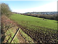
8
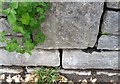
Ordnance Survey Cut Mark
This OS cut mark can be found on the wall north side of the Brynna Road. It marks a point 95.399m above mean sea level.
Image: © Adrian Dust
Taken: 28 Apr 2018
0.21 miles