IMAGES TAKEN NEAR TO
The Patch, PONTYCLUN, CF72 9LF
Introduction
This page details the photographs taken nearby to The Patch, CF72 9LF by members of the Geograph project.
The Geograph project started in 2005 with the aim of publishing, organising and preserving representative images for every square kilometre of Great Britain, Ireland and the Isle of Man.

There are currently over 7.5m images from over14,400 individuals and you can help contribute to the project by visiting https://www.geograph.org.uk
Image Map
Images are licensed for reuse under creativecommons.org/licenses/by-sa/2.0
Notes
- Clicking on the map will re-center to the selected point.
- The higher the marker number, the further away the image location is from the centre of the postcode.
Image Listing (98 Images Found)
Images are licensed for reuse under creativecommons.org/licenses/by-sa/2.0
Image
Details
Distance
1
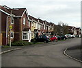
Houses in The Patch, Llanharry
The Patch is a cul-de-sac connecting with Llanharry Road behind the camera.
A yellow Neighbourhood Watch Area notice is on the lamppost on the left.
Image: © Jaggery
Taken: 13 Apr 2021
0.02 miles
2
Llys Joseph brick houses, Llanharry
Looking north along the road name Llys Joseph from the corner of Llanharry Road.
Image: © Jaggery
Taken: 13 Apr 2021
0.02 miles
4
Up The Patch, Llanharry
Looking across Llanharry Road up the cul-de-sac named The Patch towards a white 21st century house in April 2021. The house was not in an August 2009 Google Street View.
Image: © Jaggery
Taken: 13 Apr 2021
0.04 miles
5
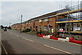
Brick houses beyond a building site in Llanharry
On the north side of Llanharry Road west of this https://www.geograph.org.uk/photo/6809228 building site viewed in April 2021.
Image: © Jaggery
Taken: 13 Apr 2021
0.04 miles
6
Brick houses on the north side of Llanharry Road, Llanharry
Looking past the Llys Joseph junction in April 2021.
Image: © Jaggery
Taken: 13 Apr 2021
0.04 miles
7
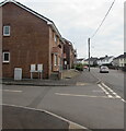
Junction of Llys Joseph and Llanharry Road, Llanharry
From the left, the road named Llys Joseph joins Llanharry Road.
Image: © Jaggery
Taken: 13 Apr 2021
0.05 miles
8
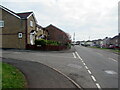
Junction of The Patch and Llanharry Road, Llanharry
From the left, the cul-de-sac named The Patch joins Llanharry Road.
Image: © Jaggery
Taken: 13 Apr 2021
0.05 miles
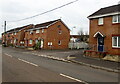
9
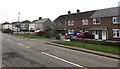
Housing variety, Llanharry Road, Llanharry
Row of houses on the right. Semi-detached houses on the left.
Image: © Jaggery
Taken: 13 Apr 2021
0.06 miles
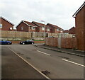
10
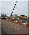
Crane in a construction site, Llanharry
Viewed across Llanharry Road in April 2021.
Image: © Jaggery
Taken: 13 Apr 2021
0.06 miles