IMAGES TAKEN NEAR TO
Clos Brenin, PONTYCLUN, CF72 9GA
Introduction
This page details the photographs taken nearby to Clos Brenin, CF72 9GA by members of the Geograph project.
The Geograph project started in 2005 with the aim of publishing, organising and preserving representative images for every square kilometre of Great Britain, Ireland and the Isle of Man.

There are currently over 7.5m images from over14,400 individuals and you can help contribute to the project by visiting https://www.geograph.org.uk
Image Map
Images are licensed for reuse under creativecommons.org/licenses/by-sa/2.0
Notes
- Clicking on the map will re-center to the selected point.
- The higher the marker number, the further away the image location is from the centre of the postcode.
Image Listing (29 Images Found)
Images are licensed for reuse under creativecommons.org/licenses/by-sa/2.0
Image
Details
Distance
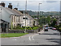
1
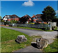
Clos Brenin houses in Brynsadler
Viewed from the edge of the A4222 Cowbridge Road.
Image: © Jaggery
Taken: 12 Jun 2014
0.07 miles
2
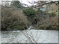
Outfall of the Nant Felin-fach into the River Ely
Image: © John Lord
Taken: 16 Jan 2018
0.09 miles
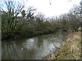
3
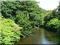
Ely River, Brynsadler
The river flows towards the A4222 Cowbridge Road bridge. A few metres beyond the left edge of the view, a stream (Nant Felin-fach) flows into the Ely. http://www.geograph.org.uk/photo/4023229
Image: © Jaggery
Taken: 12 Jun 2014
0.09 miles
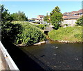
5
River Ely from bridge on the A4222 at Pontyclun.
Image: © Mick Lobb
Taken: 8 Jul 2008
0.09 miles
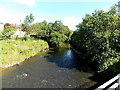
6
Stream and river confluence in Brynsadler
Viewed from the A4222 Cowbridge Road. In the middle of the view, the stream
Nant Felin-fach emerges from under a road bridge to join the much wider Ely River.
Image: © Jaggery
Taken: 12 Jun 2014
0.10 miles
7
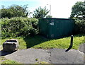
WWU (Wales & West Utilities) Gas Installation, Brynsadler
Located at the edge of the A4222 Cowbridge Road on a bank of the Ely River. The identifier on the dark green box is BREWERY (PONTYCLUN) DG BRYNSADLER PONTYCLUN. An EX in a black-lined yellow triangle indicates a potentially explosive atmosphere - smoking prohibited. A notice shows a WWU Plant Protection phone number to ring before beginning any works on, or within 10 metres of, this site.
Image: © Jaggery
Taken: 12 Jun 2014
0.10 miles
8
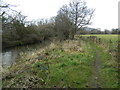
Brynsadler Bridge Riverside Walk, Brynsadler
Footpath beside the River Ely
Image: © John Lord
Taken: 16 Jan 2018
0.10 miles
10

Brynsadler Bridge
Carrying the A4222 over the River Ely.
Image: © John Lord
Taken: 16 Jan 2018
0.11 miles