IMAGES TAKEN NEAR TO
Llwyn Onn, PONTYCLUN, CF72 9EU
Introduction
This page details the photographs taken nearby to Llwyn Onn, CF72 9EU by members of the Geograph project.
The Geograph project started in 2005 with the aim of publishing, organising and preserving representative images for every square kilometre of Great Britain, Ireland and the Isle of Man.

There are currently over 7.5m images from over14,400 individuals and you can help contribute to the project by visiting https://www.geograph.org.uk
Image Map
Images are licensed for reuse under creativecommons.org/licenses/by-sa/2.0
Notes
- Clicking on the map will re-center to the selected point.
- The higher the marker number, the further away the image location is from the centre of the postcode.
Image Listing (44 Images Found)
Images are licensed for reuse under creativecommons.org/licenses/by-sa/2.0
Image
Details
Distance
1

Llwyn On, Pontyclun
Modern houses on the south side of Ash Grove. Llwyn On leads to houses in another street, Coed Mieri.
Image: © Jaggery
Taken: 5 Jun 2014
0.04 miles
2
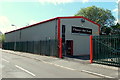
Floor-De-Lee in Pontyclun
Supplier and installer of flooring, located in Ash Grove, Ely Valley Business Park.
Image: © Jaggery
Taken: 5 Jun 2014
0.06 miles
3
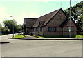
Tylagarw Community Centre, Pontyclun
On the corner of Ash Grove and Llwyn On.
Image: © Jaggery
Taken: 5 Jun 2014
0.07 miles
4
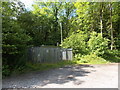
Fenced gas installation at the eastern entrance to Coed Trecastell
Located a few metres left of the entrance seen here. http://www.geograph.org.uk/photo/4026596 The identifier on the Wales & West Utilities (WWU) gas installation is COED CAE LANE DG TYLA GARW PONTYCLUN.
An EX in a black-lined yellow triangle indicates a potentially explosive atmosphere - smoking prohibited. A notice shows a WWU Plant Protection phone number to ring before beginning any works on, or within 10 metres of, this site.
Image: © Jaggery
Taken: 5 Jun 2014
0.07 miles
5
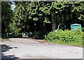
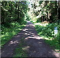
Eastern entrance to Coed Trecastell near Pontyclun
Coed Trecastell is a Forestry Commission Wales woodland.
Image: © Jaggery
Taken: 5 Jun 2014
0.08 miles
7
No motorbikes in Coed Trecastell near Pontyclun
The No motorbikes sign is alongside a track through Forestry Commission Wales woodland.
Image: © Jaggery
Taken: 5 Jun 2014
0.10 miles
8
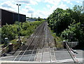
Distant train speeds towards Coedcae Lane level crossing, Pontyclun
Viewed from this http://www.geograph.org.uk/photo/4014468 footbridge.
In the foreground, the level crossing barriers descended a few minutes ago.
In a few seconds the distant train will speed through the level crossing.
Image: © Jaggery
Taken: 5 Jun 2014
0.10 miles
9
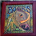
The Boar's Head name sign, Pontyclun
On the wall here. http://www.geograph.org.uk/photo/4014381
Image: © Jaggery
Taken: 5 Jun 2014
0.10 miles
10
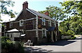
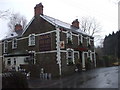
The Boar's Head Pontyclun
Pub in Tyla Garw, Pontyclun, near a railway level crossing.
Image: © Jaggery
Taken: 5 Jun 2014
0.10 miles