IMAGES TAKEN NEAR TO
Lewis Street, PONTYCLUN, CF72 9AD
Introduction
This page details the photographs taken nearby to Lewis Street, CF72 9AD by members of the Geograph project.
The Geograph project started in 2005 with the aim of publishing, organising and preserving representative images for every square kilometre of Great Britain, Ireland and the Isle of Man.

There are currently over 7.5m images from over14,400 individuals and you can help contribute to the project by visiting https://www.geograph.org.uk
Image Map
Images are licensed for reuse under creativecommons.org/licenses/by-sa/2.0
Notes
- Clicking on the map will re-center to the selected point.
- The higher the marker number, the further away the image location is from the centre of the postcode.
Image Listing (130 Images Found)
Images are licensed for reuse under creativecommons.org/licenses/by-sa/2.0
Image
Details
Distance
2
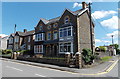
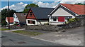
Cwrt Bethel, Pontyclun
Aelwyd Housing Association flats on the corner of Llantrisant Road and Lewis Street.
The name and corner location suggest it's likely that there used to be a Bethel chapel here.
In June 2014, the Bethel Baptist Centre is in a modern building nearby. http://www.geograph.org.uk/photo/4017284
Image: © Jaggery
Taken: 5 Jun 2014
0.03 miles
3

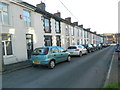
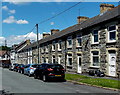
Contrasting sides of Lewis Street, Pontyclun
On the west side of the A4222 Llantrisant Road.
Image: © Jaggery
Taken: 5 Jun 2014
0.04 miles
4
Lewis Street, Pontyclun
Viewed across the A4222 Llantrisant Road looking towards distant houses
in Lon Elai on a bank of the Ely River. Cwrt Bethel http://www.geograph.org.uk/photo/4017348 is on the left.
Image: © Jaggery
Taken: 5 Jun 2014
0.04 miles
5
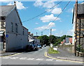
Llantrisant Road houses, Pontyclun
The A4222, here named Llantrisant Road, is the main road through Pontyclun. Pontyclun Funeral Services and Griffiths Memorials Monumental Masons http://www.geograph.org.uk/photo/4017375 are on the right, in Clun Avenue.
Image: © Jaggery
Taken: 5 Jun 2014
0.05 miles
6
Row of houses in School Street, Pontyclun
Looking NW towards Lon Elai on a bank of the River Ely. There is no longer a school in School Street. Old School Surgery http://www.geograph.org.uk/photo/4017468 has occupied that site since 1992.
Image: © Jaggery
Taken: 5 Jun 2014
0.05 miles
7

School Street, Pontyclun
Looking NW towards Lon Elai on a bank of the River Ely. There is no longer a school in School Street. Old School Surgery http://www.geograph.org.uk/photo/4017468 has occupied that site on the left since 1992.
Image: © Jaggery
Taken: 5 Jun 2014
0.06 miles
8
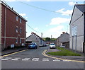
Merthyr Street bungalows, Pontyclun
The Maelog Close junction is a few metres beyond the bungalow on the left.
Image: © Jaggery
Taken: 5 Jun 2014
0.06 miles
9
Merthyr Street, Pontyclun
Viewed across the A4222 Llantrisant Road.
At the far end of Merthyr Street is Maelog Close, on a bank of the Ely River.
Image: © Jaggery
Taken: 5 Jun 2014
0.06 miles
10
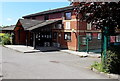
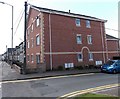
Old School Surgery, Pontyclun
Set back from School Street in a surgery that was purpose-built in 1992.
Image: © Jaggery
Taken: 5 Jun 2014
0.06 miles