IMAGES TAKEN NEAR TO
Green Meadow, PONTYCLUN, CF72 8XT
Introduction
This page details the photographs taken nearby to Green Meadow, CF72 8XT by members of the Geograph project.
The Geograph project started in 2005 with the aim of publishing, organising and preserving representative images for every square kilometre of Great Britain, Ireland and the Isle of Man.

There are currently over 7.5m images from over14,400 individuals and you can help contribute to the project by visiting https://www.geograph.org.uk
Image Map
Images are licensed for reuse under creativecommons.org/licenses/by-sa/2.0
Notes
- Clicking on the map will re-center to the selected point.
- The higher the marker number, the further away the image location is from the centre of the postcode.
Image Listing (15 Images Found)
Images are licensed for reuse under creativecommons.org/licenses/by-sa/2.0
Image
Details
Distance
1
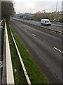
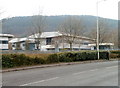
A4119 to Llantrisant
Southbound carriageway of the A4119.
Image: © Alan Hughes
Taken: 5 Nov 2018
0.04 miles
2
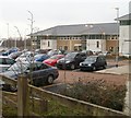
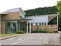
Two NHS offices, Magden Park, Llantrisant
Side by side in Magden Park are the offices of the Welsh Bowel Screening Centre on the left, and the Cervical Screening Centre. Both offices are part of the National Health Service programme to detect the early stages of cancer.
Image: © Jaggery
Taken: 9 Feb 2011
0.07 miles
3
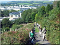
Tuag at y Graig / Towards the Graig
Cerddwyr yn dilyn llwybr cyhoeddus lan tuag at y Graig.
Walkers ascending a public footpath toward y Graig (trans. the hill).
Image: © Alan Richards
Taken: 21 Sep 2008
0.09 miles
4
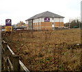
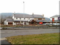
Premier Inn, Llantrisant
Hotel located at Gwaun Elai, Magden Park, Llantrisant. This is one of more than 500 Premier Inns in the UK and Ireland.
In the background is The Longbow http://www.geograph.org.uk/photo/2263957 Beefeater restaurant and pub.
Image: © Jaggery
Taken: 9 Feb 2011
0.11 miles
5
The Longbow, Llantrisant
Recently-built Beefeater restaurant and pub, Gwaun Elai, Magden Park, Llantrisant.
On the right is a Premier Inn. http://www.geograph.org.uk/photo/2263951
Image: © Jaggery
Taken: 9 Feb 2011
0.17 miles
7
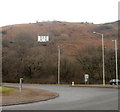
White house on the hill, Llantrisant
Viewed from a roundabout on Ely Valley Road (A4119).
Image: © Jaggery
Taken: 9 Feb 2011
0.19 miles
8
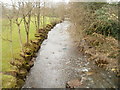
River Ely downstream, Ynysmaerdy
The view downstream from a footbridge http://www.geograph.org.uk/photo/2263788 linking the Royal Glamorgan Hospital car park with the hospital buildings.
Image: © Jaggery
Taken: 9 Feb 2011
0.19 miles
10
British Airways Avionics Engineering, Llantrisant
Aviation plant located in Gwaun Elai, close to the junction with the A4119.
Image: © Jaggery
Taken: 9 Feb 2011
0.21 miles